Lunokhod 2
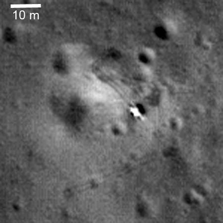 NASA/GSFC/Arizona State University. Public domain (NASA / US government work).
Overview
Section titled “Overview”Lunokhod 2 was the second and last Soviet lunar rover, delivered to the Moon by the Luna 21 lander. Luna 21 launched on 8 January 1973 on a Proton-K with a Blok D upper stage, entered lunar orbit on 12 January and landed at 22:35 UT on 15 January inside the 55 km crater Le Monnier, on the eastern margin of Mare Serenitatis about 180 km north of the Apollo 17 landing site [44]. The rover drove off the lander at 01:14 UT on 16 January [44], landing at approximately 30.4 E, 25.97 N in the southern part of Le Monnier [39].
The vehicle was a direct evolution of Lunokhod 1, with the same self-propelled chassis and the same sealed, pressurized instrument compartment [39]. It operated for five lunar days and stopped on 10 May 1973, having driven 39.16 km, a distance no vehicle on another world exceeded until Opportunity’s odometer passed it in July 2014 [44].
The only other wheeled vehicles to operate on the Moon at the time were crewed. The Apollo Lunar Roving Vehicle covered 27.9, 26.6 and 34.8 km of odometer distance on Apollo 15, 16 and 17, navigating by a dead-reckoning system of a directional gyro, four wheel odometers and a sun shadow device, with closure error under 200 m on Apollo 15 and zero on Apollos 16 and 17 [10]. Lunokhod 2 had to do comparable distances with no crew, no gyro-based navigation after its attitude hardware failed, and a ground crew 2.6 s of light time away. Every later lunar rover, flown or proposed, is read against these two baselines, and the sections below name which of its designs flew, which were tested on the ground, and which exist only as concepts.
Specifications
Section titled “Specifications”| Parameter | Lunokhod 2 | Lunokhod 1 |
|---|---|---|
| Rover mass | 836 kg | 756 kg |
| Rover mass, second value | 840 kg, 1814 kg with lander | 756 kg |
| Dimensions | 170 x 160 x 135 cm | about 2.2 m long, 2.2 m wide |
| Solar array | 250 A-h, gallium arsenide | 200 A-h, silicon |
| Wheel diameter / width | 510 mm / 200 mm | 510 mm / 200 mm |
| Track gauge | 1600 to 1700 mm | 1700 mm wheelbase |
| Commanded speeds | 0.8 and 2.0 km/h | about 0.93 and 2 km/h |
| Navigation cameras | 3 MKTV | 2 MKTV |
| Navigation frame interval | about 6 s | about 20 s |
Source: [39], except the second mass value, wheelbase and frame timing [41], and the Lunokhod 1 dimensions and speeds [40].
Mission profile
Section titled “Mission profile”| Parameter | Value |
|---|---|
| Launch | 8 January 1973, Proton-K with Blok D |
| Landing | 22:35 UT, 15 January 1973, crater Le Monnier |
| Landing point | approximately 30.4 E, 25.97 N |
| Rover egress | 01:14 UT, 16 January 1973 |
| End of operations | 10 May 1973 |
| Surface lifetime | 139 days, 5 lunar days |
| Distance driven | 39.16 km, 37 km as measured at the time |
| Average achieved speed | 340 m/h, against 140 m/h for Lunokhod 1 |
Source: [44] for launch, landing and egress timing; [39] for landing point, distance and speed; [41] for surface lifetime.
Luna 21 descended from a 90 by 100 km parking orbit with perilune lowered to 16 km and held for 40 orbits; the braking rocket put the lander into free fall, main thrusters fired 750 m above the surface and shut down at 22 m, secondary thrusters shut down at 1.5 m, and landing was a free fall from that height [41].
Mobility
Section titled “Mobility”Eight wheels, four per side, each independently driven with its own motor and brake, on a chassis carried over unchanged from Lunokhod 1. Each wheel is built from three titanium rings 510 mm in diameter with 16 spokes wrapped in a metallic mesh, 200 mm wide, on a track gauge of 1600 to 1700 mm; Lunokhod 1’s wheelbase was 1.7 m [41]. Grousers are fitted across the mesh. Lunokhod 1 itself drove 9.93 km over its mission [44]; a contemporary account gave 9200 m as its closed-loop traverse to date at a May 1971 symposium, six months into that mission [37]. Lunokhod 1’s momentum on the Moon corresponded to an estimated lunar weight in excess of 900 N [37].
Average specific ground pressure at a nominal 30 mm sinkage is 0.05 kg/cm2, about 4.9 kPa [39]. Grousers disturb the soil enough that Lunokhod tracks are identifiable in LRO Narrow Angle Camera frames, while ungrousered Apollo LRV tracks are hard to see outside the descent-stage blast zone at similar wheel loading. Sinkage was normally about 2 cm, rising to more than 20 cm near fresh impact craters [41].
There is no steering mechanism. The vehicle turns by differential wheel speed and can counter-rotate the two sides to turn in place. Turning radius in motion is typically 3 m and turn-in-place radius 0.8 m [39]. Turn-in-place locations are identifiable in LRO images from the disturbed patches they left. Skid steering scrubs the wheels laterally through the soil on every turn.
Wheel design space
Section titled “Wheel design space”The wheel is where the lunar soil meets the vehicle, and the candidate list narrowed quickly under test. A comparative program on five candidate lunar wheels (pneumatic, Bendix, Boeing/GM, Grumman and the SLRV wheel) in fine sand at five strength levels found pull coefficient independent of wheel load below about 220 N, and found that none of the original wheels could be relied on to climb a 35 degree slope: the Bendix wheel reached about 28 to 30 degrees, the Boeing/GM and Grumman wheels about 15 to 20 degrees, and grousers or reduced stiffness raised pull at a cost in other properties [5]. The Apollo wire mesh wheel that resulted is documented as a sequence of fixes to observed failures: a woven precrimped carcass replaced looped wire intersections that fatigued, a titanium inner frame replaced rubber inner tubes after boulder-field damage at Yuma, and segmented tread strips replaced continuous strips that overstressed the wires [4]. Lunokhod took the other route, a rigid mesh-wrapped wheel with grousers and eight independent drives.
Prediction of what these wheels would do on the Moon was checked against the Apollo 15 flight. A pre-flight model combining Bekker-type soil-vehicle equations with slope and roughness spectra overpredicted LRV energy consumption with a median deviation of about 30 percent; the authors judged this satisfactory, and also record that the LRV carried no instrumentation for continuous performance monitoring and never approached its capability limits, so no limiting performance data exist [3]. Apollo 16 recorded LRV wheel tracks 0 to 5 cm deep, averaging 1.25 cm [1], against the 2 cm normal sinkage reported for Lunokhod 2. Cone penetration resistance measured in 1 g test beds has to be corrected to lunar gravity, and tests at 1/6, 1 and 2 g aboard a KC-135 showed resistance falling linearly with the gravity ratio [7].
Later wheel work is ground test and design study, not flight. A discrete element model of a lugged wheel was extended to sloped terrain and validated on a JAXA test bed with FJS-1 simulant, selecting a 250 mm rim diameter, 100 mm wide wheel with 18 lugs for a small rover concept [18]. The Scarab rover, a 280 kg four-wheel skid-steered vehicle built in 2007 for drilling in permanently shadowed craters, used a passive rocker pair with a differencing linkage and measured a drawbar pull of 0.7 times vehicle weight in mixed grain sand [15]. The Resource Prospector rover prototype, a 300 kg vehicle with four hub-motor wheels, offset four-wheel steering and active suspension, replaced skid steering so that the solar array could stay sun-pointed while roving, and was built and driven as a prototype [14]. ATHLETE, a six-limbed wheel-on-limb vehicle of roughly 850 kg in its first form, takes the opposite position on margin: wheels sized for nominal terrain, with the ability to lock them and walk out of soft ground [16]. None of these has operated on the Moon; Lunokhod and the Apollo LRV remain the only lunar wheeled flight evidence.
Two commanded speeds were available, 0.8 km/h and 2.0 km/h; achieved average over the whole mission was 340 m/h. The same chassis design operated on slopes up to 32 degrees on Lunokhod 1 [41]. Commanded speed and achieved speed differ sharply in practice: cycle-by-cycle averages reconstructed for Lunokhod 1 range from 0.01 to 0.17 km/h [40].
For comparison, the contemporary Apollo Lunar Roving Vehicle cruised at 6 to 7 km/h with a 13 km/h maximum, and a generic wheeled lunar vehicle needs 7 to 10 kPa of ground contact pressure capability, with terrain roughness at this scale imposing a parasitic energy cost comparable to a 1.5 degree climb on a smooth, rigid slope; reviews of lunar rover mobility have recommended retaining the capability to climb and descend slopes of about 25 degrees [41].
Terrain worked was not gentle. The traverse crossed transitional mare to highland ground, the Tangled Hills, and the Fossa Recta graben, roughly 19 km long, 400 m wide and 20 to 50 m deep, with slopes up to 20.3 degrees measured on a 5 m baseline and a total elevation range along the route of 144 m. During the fourth lunar day the rover worked to the edge of a tectonic fault in ground littered with blocks 2 to 3 m across [44].
Orbital data now bound how representative this terrain is. Stereo digital terrain models from the LROC Narrow Angle Camera, registered to LOLA profiles, give slope statistics for 112 globally distributed sites, 81 highland and 31 mare [17]; the Lunokhod 2 area, 82 percent below 7 degrees, is one sample of that population [39]. Block populations that decide whether a rover can pick a path were first characterized from Lunar Orbiter and Surveyor imagery: an empirical relation of block size to crater diameter [8] and cumulative size-frequency distributions at the Surveyor landing sites [19]. Soil friction angle has also been inferred from boulder-track geometry at 19 sites on Lunar Orbiter photographs [9].
The soil model the Lunokhod penetrometer readings are compared against comes from the Apollo program. The consolidated model gives bulk density rising with depth, with a best estimate of 1.50 g/cm3 over the top 15 cm and 1.74 g/cm3 at 30 to 60 cm, friction angle 35 to 50 degrees and cohesion 0.1 to 1.0 kN/m2 [2]. The standard compilation of in situ, sample and remote-sensing values, which draws on Surveyor, Luna, Lunokhod and Apollo, is Chapter 9 of the Lunar Sourcebook [6]. The Soviet and American values are not independent in method and are not measured by the same instruments, so agreement between them is a consistency check and not a calibration.
Power and energy
Section titled “Power and energy”Solar, with battery buffering, and a polonium-210 radioisotope heat source for the night. The solar array is mounted on the underside of a large hinged lid that covers the instrument compartment; the lid opens during the lunar day to expose the array and closes at night.
Lunokhod 2 replaced Lunokhod 1’s silicon cells with gallium arsenide, raising total capacity from 200 A-h to 250 A-h [39]. The rover navigated on battery and stopped periodically to recharge from the array.
Operation was confined to the lunar day. Each of the four lunar nights was spent parked at a fixed stop with the lid closed, the vehicle surviving on the isotope heater; the overnight stop coordinates for all four nights have been recovered from LRO imagery.
Thermal
Section titled “Thermal”The top of the instrument compartment is a thermal radiator and the retractable lid over it is the control element: open by day to radiate waste heat while the array underneath collects power, closed at night to cut radiative loss while the polonium-210 source keeps the compartment warm. The compartment is sealed and pressurized [39].
The design has one failure mode and it is what ended the mission. On 20 April the rover drove into a small, steep-sided crater; during the attempt to climb out the open lid contacted the crater wall and scooped soil onto the radiator [39]. With the radiator obscured, waste heat could no longer be rejected. Internal temperature became critical on 10 May and operations stopped, with radio contact lost the following day due to overheating of the vehicle body [39]. An internal Soviet report puts the end of operations at 12:25 UT on 10 May, after temperatures reached 43 to 47 C [44]. The mission was announced as over on 3 June 1973.
Soil on a thermal control surface raises its solar absorptance sharply: 11 percent areal dust coverage doubles the absorptance of a thermal control surface, and fine dust below 34 micrometers at 4.5 percent coverage raised absorptance to 0.245, of which a nitrogen jet recovered only 2 percent [36]. Dust contamination of Apollo 12’s own thermal control surfaces, by comparison, drove a 68 degree Fahrenheit temperature excess on the affected hardware [36]. The lid is simultaneously the radiator cover, the solar array support and the night insulation, so a single terrain contact removed power collection, heat rejection and night survival together, the kind of coupled thermal, dust and terrain constraint common to lunar rover designs generally; later reviews of rover concept studies concluded that modularity, rather than any single subsystem choice, is the single most important factor in developing a viable surface mobility vehicle [48].
Apollo experience shows the lid contact was one case of a general problem. A review of the mission reports of all six landings sorted dust problems into nine categories, and found that brushing worked only for the easy ones: clogging, abrasion and radiator degradation were not mitigable that way [11]. The founding NASA study of dust on power system surfaces built accumulation and performance-loss models from Apollo and Surveyor observations [20]. Neither source describes Lunokhod 2; they bear on it because the failure that ended the mission, soil on a radiator, is the category they find hardest to mitigate.
Compute and avionics
Section titled “Compute and avionics”There is no general-purpose onboard computer. Control is by direct command from Earth, and the onboard autonomy is limited to protective interlocks. Lunokhod 2 added an improved system of automatic locks that halted the vehicle on detecting dangerous slippage on steep slopes or excess voltage in the onboard power system. Detail on the avionics implementation is not available in the open literature consulted here.
Part of the attitude determination hardware failed shortly after landing, and was not recovered; the crew navigated for the rest of the mission from the positions of the Sun and prominent relief features in the camera views [39].
Autonomy
Section titled “Autonomy”None beyond the protective interlocks above. Direct-command teleoperation of this kind sits at the least autonomous end of the mobility-autonomy spectrum later surveyed across planetary rovers [43]. The rover was driven in near real time from Earth by a five-person crew: commander, driver, navigator, flight engineer and antenna operator [44]. Round-trip light time is about 2.6 s, and the effective control delay including operator lever actuation about 4.1 s [44].
Navigation used the MKTV small-frame television system. Lunokhod 1 carried two cameras at 950 mm above the surface, the eye height of a seated person; Lunokhod 2 added a third mounted above them at standing-person height [39]. The higher camera became the attitude reference once the attitude determination hardware failed, by making the horizon and distant relief usable. Frame interval was cut from roughly 20 s to roughly 6 s, enabled by a higher downlink data rate; chassis and commanded speeds were unchanged between the two vehicles, so frame rate rose by about a factor of three and achieved average speed by a factor of 2.4, from 140 m/h to 340 m/h [39].
Communications
Section titled “Communications”Direct to Earth. The rover carried its own radio system and did not relay through the Luna 21 lander after egress. The program’s own account attributes Lunokhod 2’s shorter navigation frame interval to a higher data transmission rate than Lunokhod 1 [39]; specific band assignments and bit rates are not published.
Payload and instruments
Section titled “Payload and instruments”The instrument complement was [44], with technical detail from the 2017 reconstruction [39]:
- An imaging system of three low-resolution navigation television cameras and four high-resolution panoramic photometers. The panoramic cameras are scanning-mirror instruments, one horizontal and one vertical on each side, producing about 3000 lines over 180 degrees by 500 samples over 30 degrees horizontally, and 6000 lines over 360 degrees by 500 samples vertically [39]. Stereo panoramas were obtained by imaging the same scene from two rover positions.
- RIFMA-M, an X-ray fluorescence spectrometer for regolith chemistry, modified from the instrument flown on Lunokhod 1.
- PrOP, a trafficability instrument mounted at the rear of the compartment, measuring the physical and mechanical properties of the regolith. It is a cone-vane penetrometer: a 60 degree cone of 5.0 cm base diameter and 4.4 cm height is pressed into the soil with an effort in excess of 20 kg, then 7.0 cm vanes are rotated through up to 90 degrees, so that a single emplacement yields both bearing strength and rotational shear strength [37].
- SG-70A, a three-component magnetometer on a 1.5 m boom, intended to measure the magnetization of individual surface targets [47]. Its fluxgate sensor covered a range of plus or minus 580 gamma, with a residual absolute error of plus or minus 3 gamma after correcting for the rover’s own magnetic contamination [47].
- AF-3L, an astrophotometer measuring sky luminosity at visible and ultraviolet wavelengths.
- The TL-2 laser retroreflector, a block of 14 prisms, 45 by 20 by 8 cm, in heat-resistant glass under multilayer insulation, with a Rubin-1 photoreceiver [39], [44].
- An X-ray telescope, an RV-2N radiation detector, and the odometer and speedometer.
Across both rovers PrOP made about 100 measurements over more than 47 km of path, penetrating to as much as 100 mm [42]. The combined result is a modal bearing capacity of 0.35 to 0.4 kg/cm2, cohesion of 0.04 to 0.06 kg/cm2, an internal friction angle of 20 to 25 degrees, and modal rotary shear resistance of 0.045 to 0.055 kg/cm2 [42]. Fitted to a Rayleigh distribution, the data give a minimum carrying-power parameter of 0.08 to 0.10 kg/cm2 and a soil nonuniformity parameter of 3.0 cm2/kg [42]. For Lunokhod 1 alone, bearing strength ranged from 0.2 to 1.0 kg/cm2 with terrain, most frequently 0.34 kg/cm2, and rotational shear from 0.02 to 0.09 kg/cm2, most frequently 0.048 kg/cm2 [37]. Individual penetrometer readings on the Lunokhod 1 route varied with terrain: 8.1 cm penetration at a 16.5 kgf cone load on the horizontal intercrater surface, 20.5 cm at 23.5 kgf on a crater slope, and 7.8 cm at 19 kgf on a crater rim [37]. Strength increases with depth, and direct numerical comparison with the Apollo penetrometer values is not valid, because the instruments sampled different depths by different methods. Laboratory testing of the returned Luna 16 and Luna 20 samples put the internal friction angle at 46 and 32 degrees respectively once compacted, and found bearing capacity to rise sharply above a bulk density of 1.4 to 1.5 g/cm3 [42]. A separate account of the Lunokhod 1 route gives a similar bearing strength range of 0.2 to 1.1 kg/cm2 and shear resistance of 0.02 to 0.09 kg/cm2 [40].
LROC Narrow Angle Camera images at 0.5 to 1.7 m/pixel resolved the Luna 21 landing site and let the exact route be followed from the rover’s own wheel tracks, giving the 39.16 km total [39]. The tracks are readable because the grousers on the Lunokhod wheels disturbed the soil strongly, unlike the grouserless Apollo rover wheels at similar wheel loading, whose tracks are hard to see outside the descent stage blast zones. Places where the rover turned in place, within a 0.8 m radius, are detectable in the images [39].
The magnetometer data were used with the Apollo 16 surface magnetometer for electromagnetic sounding of the lunar interior [45], and produced evidence of an electrical conductivity anomaly beneath Mare Serenitatis [46], [47]. About 65 percent of the horizontal magnetic fluctuations fell within a 30 to 60 degree azimuth band, modeled by a nonconducting lithosphere layer about 150 km thick beneath the highlands and 300 km thick beneath Mare Serenitatis [46]; the mean field across Le Monnier Bay itself was 20 to 30 gamma, with craters larger than 50 m carrying local anomalies of 10 to 15 gamma [47]. The comparison Apollo 16 magnetometer at the Descartes highland site recorded a remanent field of 327 gamma [46]. The retroreflector outlived everything else: 1400 ranging measurements were made from the Crimean Astrophysical Observatory’s 2.6 m telescope between 1978 and 1983 at 25 cm accuracy, terminating only with the cancellation of the Soviet lunar program, and ranging continued from other observatories afterwards [39]. The return signal is at least five times weaker than Lunokhod 1’s, possibly from dust obscuration. Reflector positions established to centimeter level define geodetic reference points for the lunar coordinate frame. Lunokhod 1’s own retroreflector, by contrast, could not be recovered at all until its position was picked out of LRO imagery in 2010, to 5 m accuracy [44].
Total imaging return was about 80,000 navigation frames and 86 panoramas, with hundreds of mechanical and chemical surveys of the soil including 25 RIFMA analyses [44].
Modes of operation
Section titled “Modes of operation”The operating cycle is imposed by illumination rather than by onboard state machines. Driving and science occur during the lunar day. At the end of each day the vehicle is parked at a chosen stop, the lid is closed, and it hibernates through the roughly 14 day night on the polonium heater, to be woken when the Sun returns [39]. Four such hibernations were completed. The protective interlocks constitute the only automatic mode transition: on detected slippage or overvoltage the vehicle stops itself.
Per lunar day the traverse distances, remeasured from orbit, were 1299 m, 10034 m, 17622 m, 9136 m and 1014 m, against mission-era odometer values of 1148, 9919, 16533, 8600 and 880 m respectively [39]. The fifth day was cut short by the radiator contamination.
Ground operations
Section titled “Ground operations”The rover was driven from Simferopol in Crimea by a dedicated crew, working from the navigation camera feed [39]. The crew composition and the general method were inherited from Lunokhod 1: a commander, driver, navigator, flight engineer and antenna operator, driving against imagery that updates every few seconds, which means committing to a heading before seeing its outcome [44]. Contemporary Soviet press reported crew pulse rates of 130 to 135 beats per minute during difficult driving [44].
Route planning used American imagery. Photographs of the surface around the Luna 21 landing site, taken before the Apollo 17 landing, were handed to a Soviet engineer at a planetary exploration conference in Moscow between 29 January and 2 February 1973, after Luna 21 had landed, and were subsequently used by the driver team to navigate [44].
The mission-era route reconstruction was a manual operations map compiled during the mission and held by the Lavochkin museum. The same LRO-based photogrammetric method was applied first to Lunokhod 1’s route in 2013 [38], then to Lunokhod 2’s in 2017, when it yielded 39.16 km against the mission estimate of 37 km and recovered the landing and overnight stop coordinates [39].
The ground-side technique has had later flight use. For Chang’e-3, the Yutu rover imaged only at waypoints, so adjacent-site stereo pairs were heavily distorted; a cross-site method of feature matching in search regions predicted from dead reckoning, followed by bundle adjustment, gave localization error of 1 to 4 percent of traverse (3.3 percent mean) against 15 percent for dead reckoning alone in a ground test, and localized Yutu over 114.8 m and 17 sites by 16 January 2014 [12]. Lunokhod crews had no equivalent and navigated from the Sun and relief. Traverse planning for a future rover, the Resource Prospector case study at a site north of Haworth Crater, is a concept study using the xGDS planning tool and was not executed [13].
What is being tried now
Section titled “What is being tried now”Lunokhod 2 was driven by a crew with no onboard terrain model. Current work on the problems it met falls into four families. None of it has driven on the Moon.
Terrain strength sensing and slip prediction (ground tested or proposed). The Lunokhod penetrometer measured strength at stops chosen by the crew. A legged scout robot now estimates regolith penetration resistance from leg forces, builds a Gaussian process strength map and converts it to slip-based traversal risk for a wheeled rover, tested in a regolith simulant bed and on dunes [21]. A proposed transfer-learning scheme would fuse wheel-slip models from earlier lunar rovers with a small post-landing calibration set [23]. A LiDAR and IMU method predicts terrain-induced vibration on a small rover [33]. Static cone penetration in a lunar simulant at 1/6 g with a magnetic levitation rig extends the gravity correction that earlier aircraft tests applied to penetrometer data [28], and a discrete element study compares Earth-based scaling methods for single-wheel mobility at 1/6 g against direct 1/6 g runs [27]. All are simulation or laboratory results.
Wheel and suspension design (ground tested). A grouser wheel with continuously variable height from 0 to 17.5 mm and 16 grousers was run in 750 trials on five surfaces [26]. Bayesian optimization of wheel geometry and steering gains over 3,000 continuum simulations was checked against three printed wheels [22]. An open mission evaluator for lunar rovers under 50 kg couples a Bekker-Wong wheel model to mass, power, thermal and traverse models and finds the binding trade shifts with mission profile [34]. A 75 kg rover concept with an actively gimbaled suspension uses one learned controller across rock fields, steps and sandy slopes [25]. Lunokhod fixed its wheel design before flight and had no means to adapt it; these remain test-bed and design studies.
Path planning that spends wheel life. A thesis adds terrain-aware curvature penalties to two planners to reduce steering-induced wheel wear [24]. Lunokhod’s skid steering scrubbed the wheels on every turn, and the penalty targets that mechanism. It has been demonstrated in planning studies, not on a flight vehicle.
Navigation and autonomy for long traverses (field tested or proposed). Lunokhod 2 lost its attitude hardware and navigated by Sun and relief. A stereo visual SLAM system adds DEM-derived height and surface-normal factors to the pose graph to cut trajectory error over long traverses [32]. A one-tonne path-to-flight rover ran lidar teach-and-repeat at an analogue site for two weeks, building 18 path segments with a semi-autonomous teach and then repeating the route autonomously with cargo [29].
Power, thermal and health management (ground tested). The failure that ended Lunokhod 2 was a thermal fault no one onboard could detect or act on. For the proposed Endurance rover, onboard power and thermal management was validated by driving a real rover in a Mars analogue yard against a simulated power and thermal model: 4.192 km in 392 minutes with four interventions, all in mobility and none in the autonomy or the power and thermal software [31]. A model-based mode estimator tracks charge and activity modes of a simplified power subsystem [30]. Anomaly detectors for the same concept were trained on 184 simulated runs because no historical mission data exist [35].
What is not established
Section titled “What is not established”The 39.16 km figure is a track-digitization length from 2.5 m/pixel imagery [39]. The authors list four sources for its disagreement with the 37 km logged from the ninth-wheel odometer and do not attribute the gap to any one; slopes are computed on a 5 m baseline, so the 20.3 degree maximum understates slope at wheel scale [39]. The Lunokhod penetrometer numbers are secondhand: the Lunokhod 1 curves were read off a projected figure whose origin the speaker obscured, and several depths were interpreted from curve shape [37]. The compiled mobility review gives Lunokhod 1 lifetime as two irreconcilable values and records that the Bekker equations failed for small rovers in 1/6 g without a magnitude [41]. No instrumented measurement of Lunokhod wheel slip, power or motor current is held, and the avionics are not described in the sources held. Whether the later concepts above meet the Lunokhod 2 terrain demands has not been shown by any flight.
References
Section titled “References”References
- Mitchell, J. K., Carrier, W. D. I., Houston, W. N., Scott, R. F., Bromwell, L. G., Durgunoglu, H. T., Hovland, H. J., Treadwell, D. D. and Costes, N. C. (1972). Soil mechanics
. NASA, NASA SP-315. Source
BibTeX
@techreport{mitchell1972soilb, title = {Soil mechanics}, author = {Mitchell, James K. and Carrier, W. D., III and Houston, William N. and Scott, Ronald F. and Bromwell, L. G. and Durgunoglu, H. T. and Hovland, H. John and Treadwell, D. D. and Costes, Nicholas C.}, number = {NASA SP-315}, pages = {xi-xii}, institution = {NASA}, year = {1972}, doi = {10.1017/cbo9780511815553.002}, abstract = {This book teaches the principles of soil mechanics to undergraduates, along with other properties of engineering materials, to which the students are exposed simultaneously. Using the critical state method of soil mechanics to study the mechanical behavior of soils requires the student to consider density alongside effective stresses, permitting the unification of deformation and strength characteristics. This unification aids the understanding of soil mechanics. This book explores a one-dimensional theme for the presentation of many of the key concepts of soil mechanics - density, stress, stiffness, strength, and fluid flow - and includes a chapter on the analysis of one-dimensional consolidation, which fits nicely with the theme of the book. It also presents some theoretical analyses of soil-structure interaction, which can be analyzed using essentially one-dimensional governing equations. Examples are given at the end of most chapters, and suggestions for laboratory exercises or demonstrations are given.} } - Mitchell, J. K., Carrier, W. D. I., Costes, N. C., Houston, W. N., Scott, R. F. and Hovland, H. J. (1974). Apollo soil mechanics experiment S-200
. NASA, NASA-CR-134306. Source
BibTeX
@techreport{mitchell1974apollo, title = {Apollo soil mechanics experiment S-200}, author = {Mitchell, James K. and Carrier, W. D., III and Costes, Nicholas C. and Houston, William N. and Scott, Ronald F. and Hovland, H. John}, number = {NASA-CR-134306}, institution = {NASA}, year = {1974}, url = {https://ntrs.nasa.gov/citations/19740019219}, abstract = {The physical and mechanical properties of the unconsolidated lunar surface material samples that were obtained during the Apollo missions were studied. Sources of data useful for deduction of soil information, and methods used to obtained the data are indicated. A model for lunar soil behavior is described which considers soil characteristics, density and porosity, strength, compressibility, and trafficability parameters. Lunar history and processes are considered, and a comparison is made of lunar and terrestrial soil behavior. The impact of the findings on future exploration and development of the moon are discussed, and publications resulting from lunar research by the soil mechanics team members are listed.} } - Costes, N. C., Farmer, J. E. and George, E. B. (1972). Mobility Performance of the Lunar Roving Vehicle: Terrestrial Studies --- Apollo 15 Results
. Conference of the International, NASA TR R-401, 19730008090. Source
BibTeX
@inproceedings{costes1972mobility, title = {Mobility Performance of the Lunar Roving Vehicle: Terrestrial Studies --- Apollo 15 Results}, author = {Costes, Nicholas C. and Farmer, John E. and George, Edwin B.}, booktitle = {Conference of the International}, number = {NASA TR R-401, 19730008090}, institution = {NASA Marshall Space Flight Center}, address = {Stockholm and Kiruna}, month = {12}, year = {1972}, url = {https://ntrs.nasa.gov/citations/19730008090}, abstract = {The constriants of the Apollo 15 mission dictated that the average and limiting performance capabilities of the first manned lunar roving vehicle be known or estimated within narrow margins. Extensive studies were conducted and are compared with the actual performance of the lunar roving vehicle during the Apollo 15 mission. From this comparison, conclusions are drawn relating to the capabilities and limitation of current terrestrial methodology in predicting the mobility performance of lunar roving vehicles under in-situ environmental conditions, and recommendations are offered concerning the performance of surface vehicles on future missions related to lunar or planetary exploration.} } - Asnani, V., Delap, D. and Creager, C. (2009). The Development of Wheels for the Lunar Roving Vehicle
. Journal of Terramechanics, NASA/TM-2009-215798, 20100000019. Source
BibTeX
@article{asnani2009development, title = {The Development of Wheels for the Lunar Roving Vehicle}, author = {Asnani, Vivake and Delap, Damon and Creager, Colin}, journal = {Journal of Terramechanics}, volume = {46}, number = {NASA/TM-2009-215798, 20100000019}, pages = {89-103}, institution = {NASA Glenn Research Center}, year = {2009}, doi = {10.1016/j.jterra.2009.02.005}, abstract = {The Lunar Roving Vehicle (LRV) was developed for NASA s Apollo program so astronauts could cover a greater range on the lunar surface, carry more science instruments, and return more soil and rock samples than by foot. Because of the unique lunar environment, the creation of flexible wheels was the most challenging and time consuming aspect of the LRV development. Wheels developed for previous lunar systems were not sufficient for use with this manned vehicle; therefore, several new designs were created and tested. Based on criteria set by NASA, the choices were narrowed down to two: the wire mesh wheel developed by General Motors (GM), and the hoop spring wheel developed by the Bendix Corporation. Each of these underwent intensive mechanical, material, and terramechanical analyses, and in the end, the wire mesh wheel was chosen for the LRV. Though the wire mesh wheel was determined to be the best choice for its particular application, it may be insufficient towards achieving the objectives of future lunar missions that could require higher tractive capability, increased weight capacity, or extended life. Therefore lessons learned from the original LRV wheel development and suggestions for future Moon wheel projects are offered.} } - Freitag, D. R., Green, A. J. and Melzer, K.-J. (1970). Performance Evaluation of Wheels for Lunar Vehicles (Summary Report)
. U.S. Army Engineer Waterways Experiment Station, Technical Report M-70-2. Source
BibTeX
@techreport{freitag1970performance, title = {Performance Evaluation of Wheels for Lunar Vehicles (Summary Report)}, author = {Freitag, Dean R. and Green, Andrew J. and Melzer, Klaus-Jurgen}, number = {Technical Report M-70-2}, institution = {U.S. Army Engineer Waterways Experiment Station}, year = {1970}, url = {https://ntrs.nasa.gov/citations/19700027358}, abstract = {Performance evaluation of lunar surface vehicle wheels in fine sand} } - Carrier, W. D. I., Olhoeft, G. R. and Mendell, W. (1991). Physical Properties of the Lunar Surface
. Lunar Sourcebook: A User's Guide to the Moon. Source
BibTeX
@incollection{carrier1991physical, title = {Physical Properties of the Lunar Surface}, author = {Carrier, W. David, III and Olhoeft, Gary R. and Mendell, Wendell}, editor = {Heiken, Grant H. and Vaniman, David T. and French, Bevan M.}, booktitle = {Lunar Sourcebook: A User's Guide to the Moon}, pages = {475--594}, publisher = {Cambridge University Press}, chapter = {9}, year = {1991}, url = {https://www.lpi.usra.edu/publications/books/lunar_sourcebook/pdf/Chapter09.pdf} } - Costes, N. C., Cohron, G. T. and Moss, D. C. (1971). Cone Penetration Resistance Test---An Approach to Evaluating In-Place Strength and Packing Characteristics of Lunar Soils
. Lunar Science Conference. Source
BibTeX
@inproceedings{costes1971cone, title = {Cone Penetration Resistance Test---An Approach to Evaluating In-Place Strength and Packing Characteristics of Lunar Soils}, author = {Costes, Nicholas C. and Cohron, G. T. and Moss, D. C.}, booktitle = {Lunar Science Conference}, volume = {3}, pages = {1973-1987}, publisher = {The M.I.T. Press}, year = {1971}, url = {https://articles.adsabs.harvard.edu/pdf/1971LPSC....2.1973C} } - Moore, H. J. (1971). Large Blocks Around Lunar Craters
. Analysis of Apollo 10 Photography and Visual Observations, NASA SP-232. Source
BibTeX
@incollection{moore1971large, title = {Large Blocks Around Lunar Craters}, author = {Moore, Henry J.}, booktitle = {Analysis of Apollo 10 Photography and Visual Observations}, number = {NASA SP-232}, pages = {26--27}, publisher = {National Aeronautics and Space Administration}, address = {Washington, D.C.}, chapter = {2}, year = {1971}, url = {https://ntrs.nasa.gov/citations/19710018395}, abstract = {Lunar geology, crater, and volcanic feature analysis from Apollo 10 visual observations and photointerpretations} } - Hovland, H. J. and Mitchell, J. K. (1973). Boulder Tracks and Nature of Lunar Soil
. The Moon. Source
BibTeX
@article{hovland1973boulder, title = {Boulder Tracks and Nature of Lunar Soil}, author = {Hovland, H. John and Mitchell, James K.}, journal = {The Moon}, volume = {6}, pages = {164--175}, year = {1973}, doi = {10.1007/bf02630660} } - Smith, E. C. and Mustin, W. C. (1973). Lunar Roving Vehicle Navigation System Performance Review
. NASA, NASA-TN-. Source
BibTeX
@techreport{anon1973lunar, title = {Lunar Roving Vehicle Navigation System Performance Review}, author = {Smith, Earnest C. and Mustin, William C.}, number = {NASA-TN-}, institution = {NASA}, year = {1973}, url = {https://ntrs.nasa.gov/citations/19740003321}, abstract = {The design and operation of the lunar roving vehicle (LRV) navigation system are briefly described. The basis for the premission LRV navigation error analysis is explained and an example included. The real time mission support operations philosophy is presented. The LRV navigation system operation and accuracy during the lunar missions are evaluated.} } - Gaier, J. R. (2007). The Effects of Lunar Dust on EVA Systems During the Apollo Missions
. NASA, NASA/TM-2005-213610/REV1. Source
BibTeX
@techreport{gaier2007effects, title = {The Effects of Lunar Dust on EVA Systems During the Apollo Missions}, author = {Gaier, James R.}, number = {NASA/TM-2005-213610/REV1}, institution = {NASA}, year = {2007}, url = {https://ntrs.nasa.gov/citations/20070021819}, abstract = {Mission documents from the six Apollo missions that landed on the lunar surface have been studied in order to catalog the effects of lunar dust on Extra-Vehicular Activity (EVA) systems, primarily the Apollo surface space suit. It was found that the effects could be sorted into nine categories: vision obscuration, false instrument readings, dust coating and contamination, loss of traction, clogging of mechanisms, abrasion, thermal control problems, seal failures, and inhalation and irritation. Although simple dust mitigation measures were sufficient to mitigate some of the problems (i.e., loss of traction) it was found that these measures were ineffective to mitigate many of the more serious problems (i.e., clogging, abrasion, diminished heat rejection). The severity of the dust problems were consistently underestimated by ground tests, indicating a need to develop better simulation facilities and procedures.} } - Wan, W., Liu, Z., Di, K., Wang, B. and Zhou, J. (2014). A Cross-Site Visual Localization Method for Yutu Rover
. IEEE Transactions on Aerospace and Electronic Systems. Source
BibTeX
@article{wan2014cross, title = {A Cross-Site Visual Localization Method for Yutu Rover}, author = {Wan, Wenhui and Liu, Z. and Di, Kaichang and Wang, B. and Zhou, Jianliang}, journal = {IEEE Transactions on Aerospace and Electronic Systems}, volume = {XL-4}, pages = {279-284}, publisher = {Copernicus GmbH}, year = {2014}, doi = {10.5194/isprsarchives-xl-4-279-2014}, abstract = {Abstract. Localization of the rover is critical to support science and engineering operations in planetary rover missions, such as rover traverse planning and hazard avoidance. It is desirable for planetary rover to have visual localization capability with high degree of automation and quick turnaround time. In this research, we developed a visual localization method for lunar rover, which is capable of deriving accurate localization results from cross-site stereo images. Tie points are searched in correspondent areas predicted by initial localization results and determined by ASIFT matching algorithm. Accurate localization results are derived from bundle adjustment based on an image network constructed by the tie points. In order to investigate the performance of proposed method, theoretical accuracy analysis on is implemented by means of error propagation principles. Field experiments were conducted to verify the effectiveness of the proposed method in practical applications. Experiment results prove that the proposed method provides more accurate localization results (1 %~4 %) than dead-reckoning. After more validations and enhancements, the developed rover localization method has been successfully used in Chang'e-3 mission operations.} } - Heldmann, J. L., Colaprete, A., Elphic, R. C., Bussey, B., McGovern, A., Beyer, R., Lees, D. and Deans, M. (2016). Site selection and traverse planning to support a lunar polar rover mission: A case study at Haworth Crater
. Acta Astronautica. Source
BibTeX
@article{heldmann2016site, title = {Site selection and traverse planning to support a lunar polar rover mission: A case study at Haworth Crater}, author = {Heldmann, Jennifer L. and Colaprete, Anthony and Elphic, Richard C. and Bussey, Ben and McGovern, Andrew and Beyer, Ross and Lees, David and Deans, Matt}, journal = {Acta Astronautica}, volume = {127}, pages = {308-320}, publisher = {Elsevier BV}, year = {2016}, doi = {10.1016/j.actaastro.2016.06.014} } - Fong, T., Bluethmann, W., Allan, M., Askew, S., Cannon, H., Deans, M., Fraser-Chanpong, N. and Markee, M. (2015). Development of the Resource Prospector Planetary Rover
. Moon - : A New Era of Coordinated Human and Robotic Exploration. Source
BibTeX
@inproceedings{fong2015development, title = {Development of the Resource Prospector Planetary Rover}, author = {Fong, Terrence and Bluethmann, William and Allan, Mark and Askew, Scott and Cannon, Howard and Deans, Matthew and Fraser-Chanpong, Nathan and Markee, Mason}, booktitle = {Moon - : A New Era of Coordinated Human and Robotic Exploration}, year = {2015}, url = {https://ntrs.nasa.gov/citations/20190000455}, abstract = {The Resource Prospector (RP) is an In-‐Situ Resource Utilization (ISRU) lunar rover mission under study by NASA. RP is planned to launch in 2020 to prospect for subsurface volatiles and to extract oxygen from lunar regolith. The mission will address several of NASA's "Strategic Knowledge Gaps" for lunar exploration. The mission will also address the Global Exploration Roadmap's strategic goal of using local resources for human exploration. The distribution of lunar subsurface volatiles drives the mission requirement for mobility. The spatial distribution is hypothesized to be governed by impact cratering with the top 0.5 m being patchy at scales of 100 m. The mixing time scale increases with depth (less frequent larger impacts). Consequently, increased mobility reduces the depth requirement for sampling. The target RP traverse will extend 1 km radially from the landing site to sample craters of varying sizes. Sampling craters with different ages will reveal possible volatile emplacement history. In 1 Ga, approximately 60-70 craters of 10 m diameter form per km2. Thus, the rover will need to sample at least ten of these craters, which may require a total traverse path length of 2-‐3 km. During 2014-2015, we developed an initial prototype rover for RP. The current design is a solar powered, four-wheeled vehicle, with hub motor drive, offset four wheel steering, and active suspension. Active suspension provides capabilities including changing vehicle ride height, traversing comparatively large obstacles, and controlling load on the wheels. All-wheel steering enables the vehicle to point arbitrarily while roving, e.g., to keep the solar array pointed at the sun while in motion. The offset steering combined with active suspension improves driving in soft soil. The rover's on-board software utilizes NASA's Core Flight Software, which is a reusable flight software environment. During 2015, we completed the initial rover software build, which provides low-level hardware interfaces, basic mobility control, waypoint driving, odometry, basic error checking, and camera services. Development of the prototype rover has enabled maturation of many of the subsystems to TRL 5. During the next year, we will conduct integrated testing of concepts of operation, navigation, and remote driving tools. In addition, we will perform environmental tests including radiation (avionics), thermal and thermal/vacuum (mechanisms), and gravity offload (mobility).} } - Bartlett, P., Wettergreen, D. and Whittaker, W. L. (2008). Design of the Scarab Rover for Mobility and Drilling in the Lunar Cold Traps
. International Symposium on Artificial Intelligence, Robotics and Automation in Space. Source
BibTeX
@inproceedings{bartlett2008design, title = {Design of the Scarab Rover for Mobility and Drilling in the Lunar Cold Traps}, author = {Bartlett, Paul and Wettergreen, David and Whittaker, William L.}, booktitle = {International Symposium on Artificial Intelligence, Robotics and Automation in Space}, address = {Los Angeles, California}, year = {2008}, url = {https://www.ri.cmu.edu/pub_files/2008/2/08isairas.scarab.bartlett.pdf} } - Wilcox, B. H. (2007). ATHLETE: A Mobility and Manipulation System for the Moon
. IEEE Aerospace Conference. Source
BibTeX
@inproceedings{wilcox2007mobility, title = {ATHLETE: A Mobility and Manipulation System for the Moon}, author = {Wilcox, Brian H.}, booktitle = {IEEE Aerospace Conference}, pages = {1-10}, year = {2007}, doi = {10.1109/aero.2007.352726}, abstract = {A robotic vehicle called ATHLETE - the all-terrain, hex-limbed, extra-terrestrial explorer is described, along with initial results of field tests of two prototype vehicles. This vehicle concept is capable of efficient rolling mobility on moderate terrain and walking mobility on extreme terrain. Each limb has a quick-disconnect tool adapter so that it can perform general-purpose handling, assembly, maintenance, and servicing tasks using any or all of the limbs.} } - Henriksen, M. R., Manheim, M. R., Burns, K. N., Seymour, P., Speyerer, E. J., Deran, A., Boyd, A. K., Howington-Kraus, E., Rosiek, M. R., Archinal, B. A. and Robinson, M. S. (2017). Extracting accurate and precise topography from LROC narrow angle camera stereo observations
. Icarus. Source
BibTeX
@article{henriksen2017extracting, title = {Extracting accurate and precise topography from LROC narrow angle camera stereo observations}, author = {Henriksen, M. R. and Manheim, M. R. and Burns, K. N. and Seymour, P. and Speyerer, E. J. and Deran, A. and Boyd, A. K. and Howington-Kraus, E. and Rosiek, M. R. and Archinal, B. A. and Robinson, M. S.}, journal = {Icarus}, volume = {283}, pages = {122-137}, year = {2017}, doi = {10.1016/j.icarus.2016.05.012} } - Nakashima, H., Fujii, H., Oida, A., Momozu, M., Kanamori, H., Aoki, S., Yokoyama, T., Shimizu, H., Miyasaka, J. and Ohdoi, K. (2010). Discrete Element Method Analysis of Single Wheel Performance for a Small Lunar Rover on Sloped Terrain
. Journal of Terramechanics, 5. Source
BibTeX
@article{nakashima2010discrete, title = {Discrete Element Method Analysis of Single Wheel Performance for a Small Lunar Rover on Sloped Terrain}, author = {Nakashima, H. and Fujii, H. and Oida, A. and Momozu, M. and Kanamori, H. and Aoki, S. and Yokoyama, T. and Shimizu, H. and Miyasaka, J. and Ohdoi, K.}, journal = {Journal of Terramechanics}, volume = {47}, number = {5}, pages = {307--321}, year = {2010}, doi = {10.1016/j.jterra.2010.04.001} } - Cintala, M. J. and Mcbride, K. M. (1995). Block distributions on the lunar surface: A comparison between measurements obtained from surface and orbital photography
. NASA, NASA-TM-104804. Source
BibTeX
@techreport{cintala1995block, title = {Block distributions on the lunar surface: A comparison between measurements obtained from surface and orbital photography}, author = {Cintala, Mark J. and Mcbride, Kathleen M.}, number = {NASA-TM-104804}, institution = {NASA}, year = {1995}, url = {https://ntrs.nasa.gov/citations/19960011631}, abstract = {Among the hazards that must be negotiated by lunar-landing spacecraft are blocks on the surface of the Moon. Unfortunately, few data exist that can be used to evaluate the threat posed by such blocks to landing spacecraft. Perhaps the best information is that obtained from Surveyor photographs, but those data do not extend to the dimensions of the large blocks that would pose the greatest hazards. Block distributions in the vicinities of the Surveyor 1, 3, 6, and 7 sites have been determined from Lunar Orbiter photography and are presented here. Only large (i.e., greater than or equal to 2.5 m) blocks are measurable in these pictures, resulting in a size gap between the Surveyor and Lunar Orbiter distributions. Nevertheless, the orbital data are self-consistent, a claim supported by the similarity in behavior between the subsets of data from the Surveyor 1, 3, and 6 sites and by the good agreement in position (if not slopes) between the data obtained from the Surveyor 3 photography and those derived from the Lunar Orbiter photographs. Confidence in the results is also justified by the well-behaved distribution of large blocks at the surveyor site. Comparisons between the Surveyor distributions and those derived from the orbital photography permit these observations: (1) in all cases but that for Surveyor 3, the density of large blocks is overestimated by extrapolation of the Surveyor-derived trends; (2) the slopes of the Surveyor-derived distributions are consistently lower than those determined for the large blocks; and (3) these apparent disagreements could be mitigated if the overall shapes of the cumulative lunar block populations were nonlinear, allowing for different slopes over different size intervals. The relatively large gaps between the Surveyor-derived and Orbiter-derived data sets, however, do not permit a determination of those shapes.} } - Katzan, C. M. and Edwards, J. L. (1991). Lunar Dust Transport and Potential Interactions with Power System Components
. NASA Lewis Research Center, NASA CR-4404. Source
BibTeX
@techreport{katzan1991lunar, title = {Lunar Dust Transport and Potential Interactions with Power System Components}, author = {Katzan, Cynthia M. and Edwards, Jonathan L.}, number = {NASA CR-4404}, institution = {NASA Lewis Research Center}, year = {1991}, doi = {10.2172/10181067}, abstract = {The lunar surface is covered by a thick blanket of fine dust. This dust may be readily suspended from the surface and transported by a variety of mechanisms. As a consequence, lunar dust can accumulate on sensitive power components, such as photovoltaic arrays and radiator surfaces, reducing their performance. In addition to natural mechanisms, human activities on the Moon will disturb significant amounts of lunar dust. Of all the mechanisms identified, the most serious is rocket launch and landing. The return of components from the Surveyor 3 provided a rare opportunity to observe the effects of the nearby landing of the Apollo 12 Lunar Module. The evidence proved that significant dust accumulation occurred on the Surveyor at a distance of 155 m. From available information on particle suspension and transport mechanisms, a series of models was developed to predict dust accumulation as a function of distance from the lunar module. The accumulation distribution was extrapolated to a future Lunar Lander scenario. These models indicate that accumulation is expected to be substantial even as far as 2 km from the landing site. Estimates of the performance penalties associated with lunar dust coverage and photovoltaic arrays are presented. Because of the lunar dust adhesive and cohesive properties, the most practical dust defensive strategy appears to be the protection of sensitive components from the arrival of lunar dust by location, orientation, or barriers.} } - Liu, S., Caporale, J. D., Zhang, Y., Liao, X., Hoganson, W., Hu, W., Misra, S., Peddinti, N., Holladay, R., Fulcher, E., Panyam, A. R., Puentes, A., Bretzfelder, J. M., Zanetti, M., Wong, U., Koditschek, D. E., Yim, M., Jerolmack, D., Sung, C. and Qian, F. (2026). Scout-Rover cooperation: online terrain strength mapping and traversal risk estimation for planetary-analog explorations. arxiv.org/abs/2602.18688v3
BibTeX
@misc{liu2026scout, title = {Scout-Rover cooperation: online terrain strength mapping and traversal risk estimation for planetary-analog explorations}, author = {Liu, Shipeng and Caporale, J. Diego and Zhang, Yifeng and Liao, Xingjue and Hoganson, William and Hu, Wilson and Misra, Shivangi and Peddinti, Neha and Holladay, Rachel and Fulcher, Ethan and Panyam, Akshay Ram and Puentes, Andrik and Bretzfelder, Jordan M. and Zanetti, Michael and Wong, Uland and Koditschek, Daniel E. and Yim, Mark and Jerolmack, Douglas and Sung, Cynthia and Qian, Feifei}, year = {2026}, url = {https://arxiv.org/abs/2602.18688v3} } - Unjhawala, H. M., Shaikh, K., Bakke, L., Serban, R. and Negrut, D. (2026). Co-Design of Rover Wheels and Control using Bayesian Optimization and Rover-Terrain Simulations. arxiv.org/abs/2602.01535v1
BibTeX
@misc{unjhawala2026co, title = {Co-Design of Rover Wheels and Control using Bayesian Optimization and Rover-Terrain Simulations}, author = {Unjhawala, Huzaifa Mustafa and Shaikh, Khizar and Bakke, Luning and Serban, Radu and Negrut, Dan}, year = {2026}, url = {https://arxiv.org/abs/2602.01535v1} } - Riccardo Viviano, S. O. A. O. M. O.-M. (2026). Fleet-To-Lab: A Transfer Learning Framework For Lunar Rover Slippage Estimation Via Model Fusion
. arXiv. Source
BibTeX
@article{riccardoviviano2026fleet, title = {Fleet-To-Lab: A Transfer Learning Framework For Lunar Rover Slippage Estimation Via Model Fusion}, author = {Riccardo Viviano, Saki Omi, Andrej Orsula, Miguel Olivares-Mendez}, journal = {arXiv}, year = {2026}, doi = {10.48550/arxiv.2609.17187}, abstract = {Accurate wheel slip estimation is essential for autonomous lunar rover mobility and navigation. Machine Learning models trained on terrestrial data generalize poorly to lunar terrain, and real lunar datasets are scarce due to the limited number of missions and costly data acquisition. We present Fleet-to-Lab, a transfer learning framework that leverages proprioceptive data collected by previously deployed heterogeneous lunar rovers to mitigate the Earth-Moon domain gap in slip estimation for a future deployable unit. We fuse several heterogeneous expert models into a single architecture, using a modest dataset collected after the rover deployment. We propose AcoMerge, a new hybrid swarm-intelligence algorithm that performs model fusion by searching for an optimal combi- nation of expert parameters. Experiments conducted in a high- fidelity physics simulation show balanced accuracy and macro- F1 improvements compared to deep model fusion baselines. AcoMerge exhibits competitive performance with joint training on deep architectures, while achieving higher macro-F1 and balanced accuracy on a smaller model. Overall, our framework shows model fusion as a possible transfer learning alternative for slippage estimation in space robotic missions with limited data.} } - Mohamed, K. (2026). Motion Planning for Minimizing Wheel Wear in Planetary Rovers on Rough Terrain. elib.dlr.de/224303/1/Mohamed_Thesis.PDF
BibTeX
@misc{karem2026, title = {Motion Planning for Minimizing Wheel Wear in Planetary Rovers on Rough Terrain}, author = {Mohamed, Karem}, year = {2026}, url = {https://elib.dlr.de/224303/1/Mohamed_Thesis.PDF} } - Bouton, A., Hasseler, T. D. and Paton, M. (2026). Learning All-Terrain Locomotion for a Planetary Rover with Actively Articulated Suspension
. arXiv. Source
BibTeX
@article{bouton2026learning, title = {Learning All-Terrain Locomotion for a Planetary Rover with Actively Articulated Suspension}, author = {Bouton, Arthur and Hasseler, Tristan D. and Paton, Michael}, journal = {arXiv}, year = {2026}, doi = {10.48550/arxiv.2606.06790}, abstract = {This paper presents ERNEST, a four-wheeled planetary rover concept equipped with a two-degree-of-freedom Active Gimbal Suspension that combines yaw and roll actuation to enable wheel reconfiguration, steering, and active load redistribution. A single neural network controller, trained to track a desired path across challenging terrain, fully unlocks the capabilities of this actuated suspension system for autonomous obstacle negotiation. A reinforcement learning framework is developed using the high-fidelity DARTS simulation engine, which combines rigid-contact dynamics and Bekker-Wong terramechanics, enabling the emergence of locomotion strategies adapted to loose-soil conditions. To obtain a single unified controller across heterogeneous terrains, a policy consolidation strategy merges the experience of terrain-specialized agents into one neural network, eliminating the need for explicit terrain classification and controller switching. The resulting controller operates on a combination of proprioceptive and exteroceptive feedback, including sparse stereo-derived terrain elevation, chassis attitude, joint states, and force-torque measurements. Zero-shot transfer to the physical rover is achieved through domain randomization, sensor noise injection, and model-to-real system identification. Experimental results demonstrate autonomous traversal of rock fields, a Bickler trap (bump obstacle), a wheel-high step, sand ripples, and sandy slopes. On a 20° sandy slope, the learned controller reduces the cost of transport by 37% on dry sand despite the additional actuation, and achieves superior performance on wet sand where the passive suspension becomes completely immobilized. A video accompanying this paper is available at https://youtu.be/d684P5a3xMc} } - Griffo, V. and Nakka, Y. K. (2026). Terrain-Adaptive Grouser Wheel for Optimal Planetary Exploration: Design and Experimental Investigation. arxiv.org/abs/2605.24311v1
BibTeX
@misc{griffo2026terrain, title = {Terrain-Adaptive Grouser Wheel for Optimal Planetary Exploration: Design and Experimental Investigation}, author = {Griffo, Vincent and Nakka, Yashwanth Kumar}, year = {2026}, url = {https://arxiv.org/abs/2605.24311v1} } - Omura, T. and Ishigami, G. (2026). Evaluating and advancing scaling methods for reliable wheel mobility prediction in low-gravity environments
. Journal of Terramechanics. Source
BibTeX
@article{omura2026evaluating, title = {Evaluating and advancing scaling methods for reliable wheel mobility prediction in low-gravity environments}, author = {Omura, Takuya and Ishigami, Genya}, journal = {Journal of Terramechanics}, volume = {122}, pages = {101104}, publisher = {Elsevier BV}, year = {2026}, doi = {10.1016/j.jterra.2025.101104}, abstract = {Predicting wheel mobility in low-gravity environments through Earth-based gravity tests offers a practical alternative to expensive parabolic flights and computationally intensive numerical simulations. However, an optimal scaling method for varying wheel speeds remains unidentified. This study systematically evaluated three scaling methods—Granular Scaling Laws (GSL), reduced-weight tests, and equal-mass tests—using Discrete Element Method simulations at three wheel angular velocities ( π / 10 , π , and 2 π rad/s). The methods were assessed based on their accuracy in predicting horizontal velocity, slip ratio, sinkage, and power consumption under free-driving conditions. GSL maintained errors below 5% across all conditions, while the equal-mass test showed velocity-dependent degradation with errors reaching 234% at high speeds. The reduced-weight test underestimated sinkage by over 100%, risking vehicle immobilization. An analytical framework employing an inertial number was developed to quantify soil flow characteristics, facilitating a comprehensive comparative analysis of the scaling methods. This analysis revealed that the equal-mass test inadequately captured dynamic flow phenomena, accounting for its velocity-dependent degradation. Conversely, GSL accurately reproduced soil flow characteristics under all conditions, enabling precise mobility predictions over a broad velocity range. These findings establish GSL as the most accurate and practical scaling approach for extraterrestrial rover mobility design and analysis. • Granular Scaling Laws predict wheel mobility within 5% across wide velocity ranges. • Reduced-weight test underestimates sinkage, increasing immobilization risk. • Equal-mass test loses accuracy as velocity increases, especially above π rad/s . • Inertial number analysis confirms GSL accurately reproduces movility and soil flow.} } - Chen, J., Li, R. and Fu, S. (2026). Influence of Low Gravity on the Penetration Resistance of Lunar Regolith
. npj Microgravity. Source
BibTeX
@article{chen2026influence, title = {Influence of Low Gravity on the Penetration Resistance of Lunar Regolith}, author = {Chen, Jun and Li, Ruilin and Fu, Shigen}, journal = {npj Microgravity}, volume = {12}, pages = {7}, year = {2026}, doi = {10.1038/s41526-026-00562-8}, abstract = {Abstract Lunar surface operations conducted by the United States and the Soviet Union confirmed that penetration resistance is a key indicator for evaluating the engineering properties of lunar regolith. To quantitatively assess the influence of reduced gravity on penetration resistance, this study employed a newly developed Geotechnical Magnetic-gravity Modeling Test (GMMT) system to perform cone penetration tests under controlled gravitational acceleration levels of 1/6 g, 1 g, and 2 g. The results indicated that the normalized penetration resistance increased as gravity decreased, and this effect was amplified at higher relative densities. To investigate the underlying mechanisms, discrete element method (DEM) simulations were conducted. The findings revealed that, in addition to gravity, in situ factors such as high relative density and irregular particle morphology also significantly enhanced penetration resistance by strengthening interparticle contact and friction. These non-gravitational effects partially offset the expected reduction in resistance under lower gravity, leading to a smaller-than-anticipated decline. This study provides new insights into the gravity-dependent penetration behavior of lunar regolith.} } - Krawciw, A., Olmedo, N., Rehmatullah, F., Desjardins-Goulet, M., Toupin, P. and Barfoot, T. D. (2026). Lunar Rover Cargo Transport: Mission Concept and Field Test
. IEEE Transactions on Field Robotics. Source
BibTeX
@article{krawciw2026lunar, title = {Lunar Rover Cargo Transport: Mission Concept and Field Test}, author = {Krawciw, Alexander and Olmedo, Nicolas and Rehmatullah, Faizan and Desjardins-Goulet, Maxime and Toupin, Pascal and Barfoot, Timothy D.}, journal = {IEEE Transactions on Field Robotics}, volume = {3}, pages = {162-176}, publisher = {Institute of Electrical and Electronics Engineers (IEEE)}, year = {2026}, doi = {10.1109/tfr.2026.3652156}, abstract = {In future operations on the lunar surface, automated vehicles will be required to transport cargo between known locations. Such vehicles must be able to navigate precisely in safe regions to avoid natural hazards, human-constructed infrastructure, and dangerous dark shadows. Rovers must be able to park their cargo autonomously within a small tolerance to achieve a successful pickup and delivery. In this field test, Lidar Teach and Repeat provides an ideal autonomy solution for transporting cargo in this way. A one-tonne path-to-flight rover was driven in a semi-autonomous remote-control mode to create a network of safe paths. Once the route was taught, the rover immediately repeated the entire network of paths autonomously while carrying cargo. The closed-loop performance is accurate enough to align the vehicle to the cargo and pick it up. This field report describes a two-week deployment at the Canadian Space Agency’s Analogue Terrain, culminating in a simulated lunar operation to evaluate the system’s capabilities. Successful cargo collection and delivery were demonstrated in harsh environmental conditions.} } - Gomez, A. R., Hasnain, Z., Ingham, M. D., Chung, S. H. and Williams, B. C. (2026). Scalable Model-Based Discrete Mode Estimation for a Lunar Rover Power System
. International Conference on Space Operations. Source
BibTeX
@inproceedings{gomez2026scalable, title = {Scalable Model-Based Discrete Mode Estimation for a Lunar Rover Power System}, author = {Gomez, Annabel R. and Hasnain, Zaki and Ingham, Michel D. and Chung, Seung H. and Williams, Brian C.}, booktitle = {International Conference on Space Operations}, publisher = {JPL Open Repository}, year = {2026}, doi = {10.48577/jpl.kmuomw}, abstract = {Reliable autonomous operation of planetary rovers requires robust onboard monitoring and diagnosis of power systems under uncertain and dynamic conditions. This work presents a model-based mode estimation framework for a simplified rover power system that combines physics-based modeling with probabilistic reasoning to estimate system and environmental state, including anomalous behavior. The approach adapts the Miniature Mode Estimation (Mini-ME) architecture to perform real-time belief tracking over discrete component modes based on noisy measurement signals including voltage, current, temperature, and state of charge, and command inputs into the system. Mini-ME is a system health management tool that monitors components, diagnoses faults in real-time, and supports downstream system recovery. We simulate the physics of the simplified power system under varying loads using a lumped parameter equivalent circuit model that captures the electrical and thermal behavior of the battery. A compiled automaton is used to encode admissible probabilistic state transitions and observation likelihoods derived from sensor models. By compiling out the combinatorial search and integrating these representations within a Bayesian update process, the system efficiently detects, isolates, and diagnoses anomalies arising from faults or unexpected operating regimes. The simulation results demonstrate accurate recovery of hidden system modes during chargedischarge cycles, illustrating how model-based reasoning supports autonomous fault diagnosis and system health management in autonomous missions. The major contribution of the paper is a thorough set of computational experiments to evaluate the performance of compiled mode estimation, versus uncompiled mode estimation, on space relevant benchmarks.} } - Patterson, K., Hasseler, T. D., Rabideau, G., Del Sesto, T., Bandyopadhyay, S., Werner, L., Hutter, M. and Ingham, M. D. (2026). Simulating Lunar Conditions for Autonomous Power and Thermal Management in the Endurance Rover
. AIAA SciTech. Source
BibTeX
@inproceedings{patterson2026simulatinglunar, title = {Simulating Lunar Conditions for Autonomous Power and Thermal Management in the Endurance Rover}, author = {Patterson, Katharine and Hasseler, Tristan D. and Rabideau, Gregg and Del Sesto, Tyler and Bandyopadhyay, Saptarshi and Werner, Lennart and Hutter, Marco and Ingham, Michel D.}, booktitle = {AIAA SciTech}, publisher = {JPL Open Repository}, year = {2026}, doi = {10.48577/jpl.v3qtub}, abstract = {The proposed Endurance lunar rover mission introduces autonomous, long-duration exploration in the challenging operating environment of the lunar South Pole–Aitken Basin. This paper adds autonomous power and thermal management to the existing autonomy capabilities on the Endurance project. This upgrade represents a step-change that enables the rover to reason about its onboard resources for the first time. The proposed testing architecture supports meaningful Earth-based field testing by coupling real hardware with simulation-inthe- loop models that capture extreme lunar thermal conditions and mission-relevant power behavior. This setup allows Endurance’s autonomy software to run closed-loop using native signals where possible, while substituting simulated lunar counterparts to expose behaviors that cannot be tested otherwise. Through extensive physical and simulated testing, covering more than 4 km of continuous driving, we show that the system can manage its internal state and resources autonomously under lunar-representative conditions, validating system-level autonomy performance. Finally, we provide a matrix of testing configurations that span different simulation fidelities and hardware integrations to support ongoing mission development.} } - Dai, A., Vila, G. C. and Gao, G. (2026). Visual SLAM with DEM Anchoring for Lunar Surface Navigation
. arXiv. Source
BibTeX
@article{adam2026, title = {Visual SLAM with DEM Anchoring for Lunar Surface Navigation}, author = {Dai, Adam and Vila, Guillem Casadesus and Gao, Grace}, journal = {arXiv}, year = {2026}, doi = {10.48550/arxiv.2603.17229}, abstract = {Future lunar missions will require autonomous rovers capable of traversing tens of kilometers across challenging terrain while maintaining accurate localization and producing globally consistent maps. However, the absence of global positioning systems, extreme illumination, and low-texture regolith make long-range navigation on the Moon particularly difficult, as visual-inertial odometry pipelines accumulate drift over extended traverses. To address this challenge, we present a stereo visual simultaneous localization and mapping (SLAM) system that integrates learned feature detection and matching with global constraints from digital elevation models (DEMs). Our front-end employs learning-based feature extraction and matching to achieve robustness to illumination extremes and repetitive terrain, while the back-end incorporates DEM-derived height and surface-normal factors into a pose graph, providing absolute surface constraints that mitigate long-term drift. We validate our approach using both simulated lunar traverse data generated in Unreal Engine and real Moon/Mars analog data collected from Mt. Etna. Results demonstrate that DEM anchoring consistently reduces absolute trajectory error compared to baseline SLAM methods, lowering drift in long-range navigation even in repetitive or visually aliased terrain.} } - Garcia, G. M., Aravecchia, S. and Olivares-Mendez, M. A. (2026). RoughSense: Lightweight Terrain-Induced Rover Vibration Prediction Using Point Clouds and IMU Feedback. arxiv.org/abs/2609.03720v1
BibTeX
@misc{garcia2026roughsense, title = {RoughSense: Lightweight Terrain-Induced Rover Vibration Prediction Using Point Clouds and IMU Feedback}, author = {Garcia, Gabriel Manuel and Aravecchia, Stephanie and Olivares-Mendez, Miguel Angel}, year = {2026}, url = {https://arxiv.org/abs/2609.03720v1} } - Reifschneider, J. (2026). RoverDevKit: An open, physics-grounded tradespace toolkit for conceptual design of lunar micro-rovers
. arXiv preprint. Source
BibTeX
@article{reifschneider2026roverdevkit, title = {RoverDevKit: An open, physics-grounded tradespace toolkit for conceptual design of lunar micro-rovers}, author = {Reifschneider, Jon}, journal = {arXiv preprint}, year = {2026}, doi = {10.48550/arxiv.2606.21755}, abstract = {Lunar micro-rovers under 50 kg are a rapidly growing vehicle class, yet open, benchmarked tools for running optimization across design trades remain scarce. Rover sizing is a highly coupled problem with a feedback loop specific to surface vehicles: a heavier rover sinks deeper into loose regolith, deeper sinkage costs more power, more power requires a larger array, and the array adds mass. We present RoverDevKit, a tradespace exploration toolkit with an open evaluator that couples a closed-form wheel-soil model with bottom-up mass, solar-power, thermal-survival, and traverse models. It is fast enough to serve as the fitness function of a multi-objective genetic algorithm (NSGA-II): one search of 3000 mission evaluations takes under a minute on a single laptop core. We use it to map the trades among distance traveled, vehicle mass, and slope capability on mare, polar, highland, and crater-rim missions. Across those missions the limiting factor changes: energy storage at high latitude, slope traction on loose highland regolith, and traverse range on mare and crater-rim terrain. The wheel-soil model matches measured single-wheel drawbar pull on two independent datasets to within the 20-30% error typically reported for this class of model, and the mass model predicts published 5-50 kg rover masses to 10.5% median absolute error. A check against five published in-class designs places them near the designs the optimizer selects. Re-running the search after applying that wheel-soil comparison error leaves these conclusions unchanged.} } - Claridge, S., Patterson, J., Hasnain, Z., Goel, A., Patterson, K., Rouquette, N. F., Wagner, C., Hasseler, T. D. and Ingham, M. D. (2026). Supervised and Unsupervised Methods for Detecting Anomalies in an Autonomous Long-range Lunar Rover
. EUROPEAN CONFERENCE OF THE PROGNOSTICS AND HEALTH MANAGEMENT SOCIETY. Source
BibTeX
@inproceedings{claridge2026supervised, title = {Supervised and Unsupervised Methods for Detecting Anomalies in an Autonomous Long-range Lunar Rover}, author = {Claridge, Sofie and Patterson, Jack and Hasnain, Zaki and Goel, Ashish and Patterson, Katharine and Rouquette, Nicolas F. and Wagner, Caleb and Hasseler, Tristan D. and Ingham, Michel D.}, booktitle = {EUROPEAN CONFERENCE OF THE PROGNOSTICS AND HEALTH MANAGEMENT SOCIETY}, publisher = {JPL Open Repository}, year = {2026}, doi = {10.48577/jpl.kqud0q}, abstract = {Autonomous space systems must navigate complex environments and accomplish concurrent tasks without continuous input and supervision from human operators. Interactions between subsystems and with the environment may lead to unintended behavior, resulting in downtime, delays, goal degradation, loss of functionality, or even catastrophic failures. The Endurance mission concept requires a lunar rover to traverse thousands of kilometers over a long period of time (multiple years) across the South Pole-Aitken Basin on the far side of the Moon. Onboard system health management is required to detect and diagnose anomalies and faults that pose a risk to mission objectives. To this end, we propose training both unsupervised and supervised machine learning models to detect and diagnose anomalies onboard a rover over the courseof a mission, supported by a pipeline for anomaly data generation that enables training and evaluation. We generate synthetic anomaly signatures using a low-fidelity mission simulator which outputs labeled datasets to enable supervised learning. We present results from a field experiment in which we deploy this supervised model as a ROS network node in a rover-ground network. In parallel, we train unsupervised models to detect anomalies in the mobility system by training on experimental field data and present results which verify the ability to detect anomalies observed by field operators as well as anomalies which were not detected by the operators. Our work demonstrates how machine learning models can detect anomalies onboard by leveraging multiple data sources, including pre-launch test data and operational data from earlier phases of the mission, and provides a pathway for improving anomaly detection as a rover’s mission progresses.} } - Gaier, J. R. (2005). The Effects of Lunar Dust on EVA Systems During the Apollo Missions
. NASA Glenn Research Center, NASA/TM-2005-213610, 20050160460. Source
BibTeX
@techreport{gaier2005effects, title = {The Effects of Lunar Dust on EVA Systems During the Apollo Missions}, author = {Gaier, James R.}, number = {NASA/TM-2005-213610, 20050160460}, institution = {NASA Glenn Research Center}, year = {2005}, url = {https://ntrs.nasa.gov/citations/20050160460}, abstract = {Mission documents from the six Apollo missions that landed on the lunar surface have been studied in order to catalog the effects of lunar dust on Extra-Vehicular Activity (EVA) systems, primarily the Apollo surface space suit. It was found that the effects could be sorted into nine categories: vision obscuration, false instrument readings, dust coating and contamination, loss of traction, clogging of mechanisms, abrasion, thermal control problems, seal failures, and inhalation and irritation. Although simple dust mitigation measures were sufficient to mitigate some of the problems (i.e., loss of traction) it was found that these measures were ineffective to mitigate many of the more serious problems (i.e., clogging, abrasion, diminished heat rejection). The severity of the dust problems were consistently underestimated by ground tests, indicating a need to develop better simulation facilities and procedures.} } - Johnson, S. W. and Carrier, W. D. I. (1972). Soil mechanics results of Luna 16 and Lunokhod 1: A preliminary report
. NASA, 19720007196. Source
BibTeX
@techreport{johnson1972soil, title = {Soil mechanics results of Luna 16 and Lunokhod 1: A preliminary report}, author = {Johnson, S. W. and Carrier, W. D., III}, number = {19720007196}, institution = {NASA}, year = {1972}, url = {https://ntrs.nasa.gov/citations/19720007196}, abstract = {The physical and mechanical properties of the lunar soil, as determined by Luna 16 and Lunokhod 1 experiments, are discussed. Data are included for interactions between vehicle wheels and the lunar soil, compressibility, resistance to penetration, and friction characteristics of the soil. The shear strength of the returned lunar soil for various bulk densities is also examined. Several potential spacecraft materials were tested in contact with lunar soil to determine their friction and wear characteristics.} } - Karachevtseva, I., Oberst, J., Scholten, F., Konopikhin, А., Shingareva, K., Cherepanova, E., Gusakova, E., Haase, I., Peters, O., Plescia, J. and Robinson, M. (2013). Cartography of the Lunokhod-1 landing site and traverse from LRO image and stereo-topographic data
. The International Journal of Robotics Research. Source
BibTeX
@article{karachevtseva2013cartography, title = {Cartography of the Lunokhod-1 landing site and traverse from LRO image and stereo-topographic data}, author = {Karachevtseva, I. and Oberst, J. and Scholten, Frank and Konopikhin, А. and Shingareva, K. and Cherepanova, E. and Gusakova, E. and Haase, I. and Peters, O. and Plescia, J. and Robinson, M.}, journal = {The International Journal of Robotics Research}, volume = {85}, pages = {175-187}, publisher = {Elsevier BV}, year = {2013}, doi = {10.1016/j.pss.2013.06.002} } - Karachevtseva, I. P., Kokhanov, A. A., Konopikhin, A. A., Nadezhdina, I. E., Zubarev, A. E., Patratiy, V. D., Kozlova, N. A., Uchaev, D. V., Uchaev, D. V., Malinnikov, V. A. and Oberst, J. (2017). Cartography of the Luna-21 landing site and Lunokhod-2 traverse area based on Lunar Reconnaissance Orbiter Camera images and surface archive TV-panoramas
. Icarus. Source
BibTeX
@article{karachevtseva2017cartography, title = {Cartography of the Luna-21 landing site and Lunokhod-2 traverse area based on Lunar Reconnaissance Orbiter Camera images and surface archive TV-panoramas}, author = {Karachevtseva, I. P. and Kokhanov, A. A. and Konopikhin, A. A. and Nadezhdina, I. E. and Zubarev, A. E. and Patratiy, V. D. and Kozlova, N. A. and Uchaev, Dm. V. and Uchaev, Dm. V. and Malinnikov, V. A. and Oberst, J.}, journal = {Icarus}, volume = {283}, pages = {104--121}, year = {2017}, doi = {10.1016/j.icarus.2016.05.021} } - Kassel, S. (1971). Lunokhod-1 Soviet Lunar Surface Vehicle
. RAND Corporation, R-802-ARPA. Source
BibTeX
@techreport{kassel1971lunokhod, title = {Lunokhod-1 Soviet Lunar Surface Vehicle}, author = {Kassel, Simon}, number = {R-802-ARPA}, institution = {RAND Corporation}, year = {1971}, url = {https://www.rand.org/pubs/reports/R0802.html} } - Kring, D. A. (2006). Lunar Mobility Review. lpi.usra.edu/science/kring/lunar_exploration/briefings/lunar_mobility...
BibTeX
@misc{kring2006lunar, title = {Lunar Mobility Review}, author = {Kring, David A.}, howpublished = {Presentation at the Lunar and Planetary Institute, Lunar Exploration Initiative}, year = {2006}, url = {https://www.lpi.usra.edu/science/kring/lunar_exploration/briefings/lunar_mobility_review.pdf} } - Leonovich, A. K., Gromov, V. V., Dmitriyev, A. D., Penetrigov, V. N., Semyonov, P. S. and Shvarev, V. V. (1978). The main peculiarities of the processes of the deformation and destruction of lunar soil
. The Soviet-American Conference on Cosmochemistry of the Moon and Planets, 19780005029. Source
BibTeX
@inproceedings{leonovich1978main, title = {The main peculiarities of the processes of the deformation and destruction of lunar soil}, author = {Leonovich, A. K. and Gromov, V. V. and Dmitriyev, A. D. and Penetrigov, V. N. and Semyonov, P. S. and Shvarev, V. V.}, booktitle = {The Soviet-American Conference on Cosmochemistry of the Moon and Planets}, number = {19780005029}, institution = {NASA}, year = {1978}, url = {https://ntrs.nasa.gov/citations/19780005029}, abstract = {The main results of study of the physical and mechanical properties of lunar soil, obtained by laboratory study of samples returned from the moon by Luna 16 and Luna 20, as well as by operation of the self-propelled Lunokhod 1 and Lunokhod 2 on the surface of the moon, are analyzed in the report. All studies were carried out by single methods and by means of unified instruments, allowing a confident comparison of the results obtained. The investigations conducted allowed the following values of the main physical-mechanical properties of lunar soil to be determined: in the natural condition the solid density corresponds to the porosity of 0.8; the modal value of the carrying capacity is 0.4 kg/square cm; adhesion is 0.04 to 0.06 kg/square cm; and the internal angle of friction is 20 to 25 degree. The main mechanisms of deformation and destruction of the soil are analyzed in the report, and the relationships between the mechanical properties and physical parameters of the soil are presented.} } - Nesnas, I. A. D. (2013). Planetary Robotic Exploration: Mobility and Autonomy
. Jet Propulsion Laboratory, California Institute of Technology. dataverse.jpl.nasa.gov/dataset.xhtml
BibTeX
@misc{nesnas2013planetary, title = {Planetary Robotic Exploration: Mobility and Autonomy}, author = {Nesnas, Issa A. D.}, publisher = {JPL Open Repository}, institution = {Jet Propulsion Laboratory, California Institute of Technology}, year = {2013}, url = {https://dataverse.jpl.nasa.gov/dataset.xhtml?persistentId=hdl:2014/44180} } - Siddiqi, A. A. (2018). Beyond Earth: A Chronicle of Deep Space Exploration, 1958-2016
. NASA, NASA SP-2018-4041. Source
BibTeX
@book{siddiqi2018beyond, title = {Beyond Earth: A Chronicle of Deep Space Exploration, 1958-2016}, author = {Siddiqi, Asif A.}, number = {NASA SP-2018-4041}, publisher = {NASA}, year = {2018}, url = {https://www.nasa.gov/wp-content/uploads/2018/09/beyond-earth-tagged.pdf} } - Vanyan, L. L., Vnutchokova, T. A., Fainberg, E. B., Eroschenko, E. A., Dyal, P., Parkin, C. W. and Daily, W. D. (1977). Electromagnetic sounding of the moon using Apollo 16 and Lunokhod 2 surface magnetometer observations /preliminary results/
. The Moon, 19780043690. Source
BibTeX
@article{vanyan1977electromagnetic, title = {Electromagnetic sounding of the moon using Apollo 16 and Lunokhod 2 surface magnetometer observations /preliminary results/}, author = {Vanyan, L. L. and Vnutchokova, T. A. and Fainberg, E. B. and Eroschenko, E. A. and Dyal, P. and Parkin, C. W. and Daily, W. D.}, journal = {The Moon}, volume = {17}, number = {19780043690}, pages = {259-262}, institution = {NASA}, year = {1977}, doi = {10.1007/bf00562199}, abstract = {A technique of deep electromagnetic sounding of the moon using simultaneous magnetic-field measurements at two lunar surface sites is described. The method, used with the assumption that deep electrical conductivity is a function only of lunar radius, has the advantage of allowing calculation of the external driving field from two surface-site measurements only and therefore does not require data from a lunar orbiting satellite. A transient-response calculation is presented for the example of a magnetic-field discontinuity, measured simultaneously by Apollo 16 and Lunokhod 2 surface magnetometers.} } - Vanyan, L. L., Vnuchkova, T. A., Egorov, I. V., Basilevsky, A. T., Eroshenko, E. G., Fainberg, E. B., Dyal, P. and Daily, W. D. (1979). Electrical conductivity anomaly beneath Mare Serenitatis detected by Lunokhod 2 and Apollo 16 magnetometers
. The Moon and the Planets, 19790068057. Source
BibTeX
@article{vanyan1979electrical, title = {Electrical conductivity anomaly beneath Mare Serenitatis detected by Lunokhod 2 and Apollo 16 magnetometers}, author = {Vanyan, L. L. and Vnuchkova, T. A. and Egorov, I. V. and Basilevsky, Alexander T. and Eroshenko, E. G. and Fainberg, E. B. and Dyal, P. and Daily, W. D.}, journal = {The Moon and the Planets}, volume = {21}, number = {19790068057}, pages = {185-192}, institution = {NASA}, year = {1979}, doi = {10.1007/bf00897087}, abstract = {Magnetic fluctuations measured by the Lunokhod 2 magnetometer in the Bay Le Monnier are distinctly anisotropic when compared to simultaneous Apollo 16 magnetometer data measured 1100 km away in the Descartes highlands. This anisotropy can be explained by an anomalous electrical conductivity of the upper mantle beneath Mare Serenitatis. A model is presented of anomalously lower electrical conductivity beneath Serenitatis and the simultaneous magnetic data from the Lunokhod 2 site at the mare edge and the Apollo 16 site are compared to the numerically calculated model solutions. This comparison indicates that the anisotropic fluctuations can be modeled by a nonconducting layer in the lunar lithosphere which is 150 km thick beneath the highlands and 300 km thick beneath Mare Serenitatis. A decreased electrical conductivity in the upper mantle beneath the mare may be due to a lower temperature resulting from heat carried out the magma source regions to the surface during mare flooding.} } - Vnuchkova, T. A., Egorov, I. V., Yeroshenko, Y. G. and Fainberg, E. B. (1977). Magnetic field in Le Monnier Bay according to data of Lunokhod 2
. The Soviet-American Conference on Cosmochemistry of the Moon and Planets, NASA-SP-370-. Source
BibTeX
@inproceedings{vnuchkova1977magnetic, title = {Magnetic field in Le Monnier Bay according to data of Lunokhod 2}, author = {Vnuchkova, T. A. and Egorov, I. V. and Yeroshenko, Ye. G. and Fainberg, E. B.}, booktitle = {The Soviet-American Conference on Cosmochemistry of the Moon and Planets}, number = {NASA-SP-370-}, institution = {NASA}, address = {Moscow}, year = {1977}, url = {https://ntrs.nasa.gov/citations/19780005010}, abstract = {The results of the first traverse measurement of the magnetic field on the surface of the Moon are analyzed. The mean value of the magnetic field in the portion of Le Monnier Bay investigated is estimated at 20-30 gammas. An anomaly of the field (10-15 gammas) was disclosed, which is confined to craters that exceed 50 meters in size.} } - Zakrajsek, J. J., McKissock, D. B., Woytach, J. M., Zakrajsek, J. F., Oswald, F. B., McEntire, K. J., Hill, G. M., Abel, P., Eichenberg, D. J. and Goodnight, T. W. (2005). Exploration Rover Concepts and Development Challenges
. Space Exploration Conference: Continuing the Voyage of Discovery, 20050175879. Source
BibTeX
@inproceedings{zakrajsek2005exploration,
  title = {Exploration Rover Concepts and Development Challenges},
  author = {Zakrajsek, James J. and McKissock, David B. and Woytach, Jeffrey M. and Zakrajsek, June F. and Oswald, Fred B. and McEntire, Kelly J. and Hill, Gerald M. and Abel, Phillip and Eichenberg, Dennis J. and Goodnight, Thomas W.},
  booktitle = {Space Exploration Conference: Continuing the Voyage of Discovery},
  number = {20050175879},
  institution = {NASA Jet Propulsion Laboratory},
  year = {2005},
  doi = {10.2514/6.2005-2525},
  abstract = {This paper presents an overview of exploration rover concepts and the various development challenges associated with each as they are applied to exploration objectives and requirements for missions on the Moon and Mars. A variety of concepts for surface exploration vehicles have been proposed since the initial development of the Apollo-era lunar rover. This paper provides a brief description of the rover concepts, along with a comparison of their relative benefits and limitations. In addition, this paper outlines, and investigates a number of critical development challenges that surface exploration vehicles must address in order to successfully meet the exploration mission vision. These include: mission and environmental challenges, design challenges, and production and delivery challenges. Mission and environmental challenges include effects of terrain, extreme temperature differentials, dust issues, and radiation protection. Design methods are discussed that focus on optimum methods for developing highly reliable, long-life and efficient systems. In addition, challenges associated with delivering a surface exploration system is explored and discussed. Based on all the information presented, modularity will be the single most important factor in the development of a truly viable surface mobility vehicle. To meet mission, reliability, and affordability requirements, surface exploration vehicles, especially pressurized rovers, will need to be modularly designed and deployed across all projected Moon and Mars exploration missions.}
}