Yutu
Program pages CNSA: Chang'e-3 probe CNSA: Yutu lunar rover
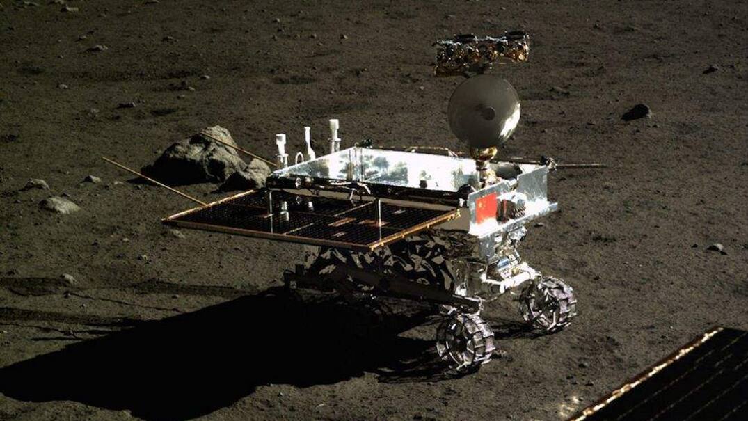 CNSA / China Lunar Exploration Program [14].
The problem
Section titled “The problem”A lunar rover has to land on terrain it cannot yet see at rover scale, locate itself on that terrain without GPS, drive without slipping into a hazard, and survive a lunar night. The Chinese landing program constrains the candidate area to an average slope of at most 8 degrees and a solar elevation of 30 to 50 degrees at landing, a limit that follows from spacecraft thermal control; latitudes below 30 degrees see large temperature swings and latitudes above 60 degrees violate the elevation window [8]. Soil strength at the site is not known in advance, so wheel design starts from Apollo and Luna priors [9]. Dead reckoning from a wheel odometer and an inertial unit accumulates error from wheel slip and drift, so a second position source is required [3]. At a landing site on the near side, commands and telemetry go through ground stations in view of the site; on the far side they go through a relay satellite [8], [23].
What has flown
Section titled “What has flown”Yutu, Chang’e-3 (2013). Chang’e-3 launched on a Long March 3B on 2 December 2013 and landed on 14 December 2013 at 19.51 W, 44.12 N in northern Mare Imbrium; the lander and rover separated and imaged one another on 15 December [6], [13], [1]. Powered descent ran from about 15 km altitude to touchdown with hazard avoidance by 3-D laser imaging from a 100 m hover, rejecting slopes steeper than 8 degrees over a 10 m baseline; the chosen 20 by 20 m area had slopes under 2 degrees and obstacles under 20 cm [16]. The rover carried four instruments: a Panoramic Camera, a Visible and Near-Infrared Imaging Spectrometer (VNIS), an Active Particle-induced X-ray Spectrometer (APXS) and a Lunar Penetrating Radar (LPR) [6]. It drove 114.8 m by cross-site visual localization, 111.2 m by DOM matching and 117.4 m by dead reckoning to waypoint N0209, each total including 4.4 m during separation [18]. The traverse crossed the ejecta of a young crater of about 450 m, and radar profiles resolved more than nine subsurface layers to about 400 m [15]. The CNSA pages give no cause for the end of mobility [1], [14], [2].
Lunokhod 1 (1970), the precedent. Lunokhod 1 is the earlier flown lunar wheeled vehicle, documented by a participant’s account of its chassis design and testing [26]. Its soil was characterized by a cone penetrometer, whose force against depth data for four terrain units were reduced to unit penetration resistance and compared with the Apollo 14 Simple Penetrometer [28]. Its traverse was later re-reconstructed on a 0.5 m per pixel LRO Narrow Angle Camera DEM, correcting the 1970 to 1971 ground-track record [27].
Yutu-2, Chang’e-4. Chang’e-4 went to the South Pole-Aitken basin with a relay satellite at Earth-Moon L2, and Yutu-2 carried a panoramic camera, a penetrating radar and a VIS-NIR spectrometer [6]. Yutu-2 reused the Chang’e-3 localization chain on the far side. At the end of lunar day 5 its odometer read 190.66 m against 186.66 m from visual localization, about 2 percent accumulated slip [3]. Onboard dead reckoning and ground visual positioning agreed to the centimeter or decimeter level over the up to 10 m between waypoints and diverged by more than 1 m where the rover slipped badly [11]. The command loop is relay-limited: a rover responds in about 10 s, the first telemetry frame arrives 80 to 100 s later and refreshes every 24 s, so confirming execution takes 3 to 4 minutes, and the rover moves at about 3.3 m/min [19]. Queqiao carries a 4.2 m parabolic relay antenna in a halo orbit at Earth-Moon L2 [23]. The LPR 60 MHz channel reached about 330 m penetration but its near-surface returns are saturated by coupling with the rover structure, so the 500 MHz channel with about 35 m penetration fills the shallow profile [21].
Zhurong, Tianwen-1 (2021), same method on Mars. Zhurong drove 2009 m of true path in 206 site operations over 360 sols while its odometer read 1921 m; onboard dead reckoning erred by 3.11 percent of traverse length [31]. Its suspension is active, with a main and auxiliary rocker arm and a clutch at the main rocker joint giving body lifting and single-wheel lifting for self-extraction [35].
What is being tried now
Section titled “What is being tried now”Visual localization and mapping. Flown. Cross-site visual localization matches ASIFT tie points between stereo pairs at adjacent waypoints inside search regions predicted from dead reckoning, rejects outliers by an inter-point distance test and closes the pose with a two-site bundle adjustment. Against indoor truth its error was 1 to 4 percent of traverse with a 3.3 percent mean, against 15 percent for dead reckoning alone; in flight it ran on a 32-core ground workstation in under 2 minutes per site including data transfer [10]. It ran at every waypoint within minutes of downlink; DOM matching, which matches orthophotos from Navcam stereo against orbital or descent basemaps, ran only where small craters or large rocks were present and was judged the most accurate [3]. The ranking rests on assertion rather than residuals against independent truth [3].
Descent-image and orbital mapping. Flown. For Chang’e-3, 180 descent images from 2.35 km to 10 m altitude with 26 ground control and 18 check points gave DEM and DOM products down to 0.05 m [3]; bundle adjustment residuals were 0.724 at control points and 0.908 at check points in the units reported [18]. The Chang’e-5 landing region near Mons Rumker has a prelanding geologic map of 14 units spanning about 3.7 to 1.2 Ga [20]. A two-stage procedure produces a continuous meter-scale orthophoto from LROC NAC images, with a planar block adjustment per subarea and heights interpolated from SLDEM2015 [25]. Rover Pancam stereo then refines the map: Yutu-2 5 cm DEMs showed the Chang’e-4 site sits on overlapping ejecta from Finsen and Alder craters [22].
Computer vision in teleoperation. Flown on Yutu-2, with the localization chain above and a Beijing Aerospace Control Center team doing the operation [11]. Commands carry a time parameter as well as a distance because a drive can fail unnoticed for minutes [19].
Wheel-soil modeling. Three families exist, none verified against Yutu flight data. A smoothed particle hydrodynamics continuum model run in Chrono, with a 137 kg six-wheel Yutu model, reproduces discrete element and single-wheel tractive force and torque curves at lower cost; it is a simulation [12]. Discrete element models resolve grains and selected lug geometry for a lunar micro rover, a 250 mm rim and 100 mm wide wheel with 18 lugs, on a JAXA slope bed in FJS-1 simulant, in two dimensions only [30]. Flight-derived estimation inverts wheel tracks: Yutu-2 track imagery gave cohesive and frictional moduli at the Chang’e-4 site [9], and a slip event on lunar day 41 gave a farside bearing capacity near 4 kPa against 2 to 3 kPa along the Lunokhod 1 traverse, with sinkage about 8 mm and never above 15 mm [4]. The continuum solver behind [12], Chrono::CRM, is validated against sphere cratering and cone penetration experiments at mean relative errors of 3.5 and 7.4 percent [34].
Regolith properties. Returned Chang’e-6 farside samples have a static angle of repose of 52.9 degrees, above any Chang’e-5 or Apollo simulant, from a D60 of 48.4 micrometers [24]. Chang’e-5 sampling used a drill with a goal of about 2 m of core, of which about 1 m was recovered [32]. At the Chang’e-3 site, Navcam stereo from 7 waypoints gave the rock size-frequency distribution on a crater ejecta blanket [17].
Thermal. The only flown vehicle-level thermal detail is a radioisotope heater unit on the APXS sensor head [5]. For the environment, Diviner nighttime cooling gives a thermal inertia of 55 J m^-2 K^-1 s^-1/2 at 273 K for the upper 4 to 7 cm [29], and the NASA specification for natural environments collects the lunar thermal and dust environments in one reference [33].
Space weathering and subsurface sounding. VNIS spectra of freshly excavated soil against weathered soil at the landing site measured the optical effect of space weathering in situ, with an optical maturity parameter of 0.34 at Site 5 and 0.18 at Site 8 [7]. LPR on Yutu was the first ground-penetrating radar operated on the lunar surface [6], [15].
The numbers
Section titled “The numbers”| Parameter | Value | Source |
|---|---|---|
| Wheels | six, three per side, two-arm linkage per wheel | [12] |
| Wheel radius, width | 0.13 m, 0.16 m | [12] |
| Mass in the published multibody model | 137.0 kg, not an agency specification | [12] |
| Lander dry mass limit | 1.22 t | [16] |
| Pancam, Navcam stereo base | 270 mm on a shared mast bar; Hazcam body-mounted | [3] |
| Pancam image | 2352 by 1728 pixels, 22.9 by 16.9 degrees | [3] |
| Navcam image | 1024 by 1024 pixels, 46.6 degrees | [3] |
| Distance, cross-site visual localization | 114.8 m | [18], [3] |
| Distance, DOM matching | 111.2 m | [18], [3] |
| Distance, dead reckoning | 117.4 m | [18] |
| Cross-site localization error, indoor truth | 1 to 4 percent, mean 3.3 percent | [10] |
| Dead reckoning error, indoor truth | 15 percent | [10] |
| VNIS spectral range | 450 to 950 nm (100 channels), 900 to 2395 nm (300 channels), 5 nm sampling | [7] |
| APXS detector | silicon drift, 7 square millimeters, better than 140 eV at 5.9 keV, 0.5 to 20 keV | [5] |
| APXS sources | 4 x 70 mCi 55Fe and 4 x 5 mCi 109Cd | [5] |
| APXS sensor head mass | 754 g | [5] |
| APXS accuracy, ground test | major elements under 15 weight percent relative at 30 mm and 30 minutes | [5] |
| APXS recommended standoff | under 50 mm | [5] |
| Regolith conductivity, surface to 1 m | 7.4e-4 to 3.4e-3 W m^-1 K^-1 | [29] |
| Regolith density, surface to 1 m | 1100 to 1800 kg m^-3 | [29] |
The APXS ground verification used two flat prepared samples and does not establish performance on irregular natural surfaces [5]. The simulation in [12] swept slip ratios from 0 to 0.8 at 0.2 m/s on soil parameter sets of 1627 to 1839 kg per cubic meter bulk density and 37.8 to 47.8 degree friction angle; tractive force and its oscillation amplitude rise with friction angle and density, and a larger rim diameter or wider wheel lowers the slip needed to climb a slope [12].
What is not established
Section titled “What is not established”No CNSA page gives Yutu’s mass, dimensions, speed, gradeability, power or thermal limits [1], [14]. No processor, memory, link frequency or data rate for the rover is published in the held sources. The cause of the end of mobility is not recorded in them [1], [14]. The localization ranking has no independent truth, and traverse totals are partly quoted from press releases [3]. The APXS test was not run on regolith at lunar temperature in vacuum [5]. The wheel-soil models are simulation or lunar-general and were not validated against Yutu flight data [12], [30]. The only soil strength estimates near the Chang’e-3 site come from later Chang’e-4 imagery analysis [9]. The 8 degree slope limit is quoted from another paper and its derivation from rover capability is not shown [8].
References
- (2017). CNSA: Chang'e-3 probe. cnsa.gov.cn/n6758824/n6759008/n6759013/c6794310/content.html
BibTeX
@misc{anon2017cnsa, title = {CNSA: Chang'e-3 probe}, organization = {cnsa.gov.cn}, year = {2017}, url = {https://www.cnsa.gov.cn/n6758824/n6759008/n6759013/c6794310/content.html} } - (2017). CNSA: Yutu lunar rover. cnsa.gov.cn/n6758823/n6758842/c6797048/content.html
BibTeX
@misc{anon2017cnsab, title = {CNSA: Yutu lunar rover}, organization = {cnsa.gov.cn}, year = {2017}, url = {https://www.cnsa.gov.cn/n6758823/n6758842/c6797048/content.html} } - Di, K., Liu, Z., Wan, W., Peng, M., Liu, B., Wang, Y., Gou, S. and Yue, Z. (2020). Geospatial technologies for Chang'e-3 and Chang'e-4 lunar rover missions
. Geo-spatial Information Science, 1. Source
BibTeX
@article{di2020geospatial, title = {Geospatial technologies for Chang'e-3 and Chang'e-4 lunar rover missions}, author = {Di, Kaichang and Liu, Zhaoqin and Wan, Wenhui and Peng, Man and Liu, Bin and Wang, Yexin and Gou, Sheng and Yue, Zongyu}, journal = {Geo-spatial Information Science}, volume = {23}, number = {1}, pages = {87--97}, year = {2020}, doi = {10.1080/10095020.2020.1718002}, abstract = {This paper presents a brief overview of the geospatial technologies developed and applied in Chang’e-3 and Chang’e-4 lunar rover missions. Photogrammetric mapping techniques were used to produce topographic products of the landing site with meter level resolution using orbital images before landing, and to produce centimeter-resolution topographic products in near real-time after landing. Visual positioning techniques were used to determine the locations of the two landers using descent images and orbital basemaps immediately after landing. During surface operations, visual-positioning-based rover localization was performed routinely at each waypoint using Navcam images. The topographic analysis and rover localization results directly supported waypoint-to-waypoint path planning, science target selection and scientific investigations. A GIS-based digital cartography system was also developed to support rover teleoperation.} } - Ding, L., Zhou, R., Yu, T., Yang, H., He, X., Gao, H., Wang, J., Yuan, Y. and Wang, J. (2024). Lunar rock investigation and tri-aspect characterization of lunar farside regolith by a digital twin
. Nature Communications. Source
BibTeX
@article{ding2024lunar, title = {Lunar rock investigation and tri-aspect characterization of lunar farside regolith by a digital twin}, author = {Ding, Liang and Zhou, Ruyi and Yu, Tianyi and Yang, Huaiguang and He, Ximing and Gao, Haibo and Wang, Juntao and Yuan, Ye and Wang, Jia}, journal = {Nature Communications}, volume = {15}, pages = {1547}, year = {2024}, doi = {10.1038/s41467-024-46233-8}, abstract = {Abstract Yutu-2 rover conducted an exciting expedition on the 41st lunar day to investigate a fin-shaped rock at Longji site (45.44°S, 177.56°E) by extending its locomotion margin on perilous peaks. The varied locomotion encountered, especially multi-form wheel slippage, during the journey to the target rock, established unique conditions for a fin-grained lunar regolith analysis regarding bearing, shear and lateral properties based on terramechanics. Here, we show a tri-aspect characterization of lunar regolith and infer the rock’s origin using a digital twin. We estimate internal friction angle within 21.5°−42.0° and associated cohesion of 520-3154 Pa in the Chang’E-4 operational site. These findings suggest shear characteristics similar to Apollo 12 mission samples but notably higher cohesion compared to regolith investigated on most nearside lunar missions. We estimate external friction angle in lateral properties to be within 8.3°−16.5°, which fills the gaps of the lateral property estimation of the lunar farside regolith and serves as a foundational parameter for subsequent engineering verifications. Our in-situ spectral investigations of the target rock unveil its composition of iron/magnesium-rich low-calcium pyroxene, linking it to the Zhinyu crater (45.34°S, 176.15°E) ejecta. Our results indicate that the combination of in-situ measurements with robotics technology in planetary exploration reveal the possibility of additional source regions contributing to the local materials at the Chang’E-4 site, implying a more complicated geological history in the vicinity.} } - Fu, X.-H., Li, C.-L., Zhang, G.-L., Peng, W.-X., Wang, H.-Y. and Cui, X.-Z. (2015). Ground-based verification and data processing of Yutu rover Active Particle-induced X-ray Spectrometer
. Chinese Physics C. Source
BibTeX
@article{fu2015ground, title = {Ground-based verification and data processing of Yutu rover Active Particle-induced X-ray Spectrometer}, author = {Fu, Xiao-Hui and Li, Chun-Lai and Zhang, Guang-Liang and Peng, Wen-Xi and Wang, Huan-Yu and Cui, Xing-Zhu}, journal = {Chinese Physics C}, volume = {39}, pages = {076002}, year = {2015}, doi = {10.1088/1674-1137/39/7/076002}, abstract = {The Active Particle-induced X-ray Spectrometer (APXS) is one of the payloads on board the Yutu rover of the Chang'E-3 mission. In order to assess the instrumental performance of APXS, a ground verification test was performed for two unknown samples (basaltic rock, mixed powder sample). In this paper, the details of the experiment configurations and data analysis method are presented. The results show that the elemental abundance of major elements can be well determined by the APXS with relative deviations <15 wt.% (detection distance=30 mm, acquisition time=30 min). The derived detection limit of each major element is inversely proportional to acquisition time and directly proportional to detection distance, suggesting that the appropriate distance should be <50 mm.} } - Ip, W.-H., Yan, J., Li, C.-L. and Ouyang, Z.-Y. (2014). Preface: The Chang'e-3 lander and rover mission to the Moon
. Research in Astronomy and Astrophysics, 12. Source
BibTeX
@article{ip2014preface, title = {Preface: The Chang'e-3 lander and rover mission to the Moon}, author = {Ip, Wing-Huen and Yan, Jun and Li, Chun-Lai and Ouyang, Zi-Yuan}, journal = {Research in Astronomy and Astrophysics}, volume = {14}, number = {12}, pages = {1511--1513}, year = {2014}, doi = {10.1088/1674-4527/14/12/001}, abstract = {The Chang'e-3 (CE-3) lander and rover mission to the Moon was an intermediate step in China's lunar exploration program, which will be followed by a sample return mission. The lander was equipped with a number of remote-sensing instruments including a pair of cameras (Landing Camera and Terrain Camera) for recording the landing process and surveying terrain, an extreme ultraviolet camera for monitoring activities in the Earth's plasmasphere, and a first-ever Moon-based ultraviolet telescope for astronomical observations. The Yutu rover successfully carried out close-up observations with the Panoramic Camera, mineralogical investigations with the VIS-NIR Imaging Spectrometer, study of elemental abundances with the Active Particle-induced X-ray Spectrometer, and pioneering measurements of the lunar subsurface with Lunar Penetrating Radar. This special issue provides a collection of key information on the instrumental designs, calibration methods and data processing procedures used by these experiments with a perspective of facilitating further analyses of scientific data from CE-3 in preparation for future missions.} } - Li, C., Liu, D., Liu, B., Ren, X., Liu, J., He, Z., Zuo, W., Zeng, X., Xu, R., Tan, X., Zhang, X., Chen, W., Zhang, H. and Wen, W. (2018). Space weathering of the Moon from in situ detection
. arXiv preprint arXiv:1812.04198. Source
BibTeX
@article{li2018space, title = {Space weathering of the Moon from in situ detection}, author = {Li, Chunlai and Liu, Dawei and Liu, Bin and Ren, Xin and Liu, Jianjun and He, Zhiping and Zuo, Wei and Zeng, Xingguo and Xu, Rui and Tan, Xu and Zhang, Xiaoxia and Chen, Wangli and Zhang, Hongbo and Wen, Weibin}, journal = {arXiv preprint arXiv:1812.04198}, year = {2018}, doi = {10.48550/arxiv.1812.04198}, abstract = {Space weathering is an important surface process occurring on the Moon and other airless bodies, especially those that have no magnetic field. The optical effects of the Moon's space weathering have been largely investigated in the laboratory for lunar samples and lunar analogues. However, duplication of the pristine regolith on Earth is not possible. Here we report the space weathering from the unique perspective of the Chang'E-3's (CE-3) "Yutu" rover, building on our previous work (Wang et al. 2017; Wu and Hapke 2018). Measurement of the visually undisturbed uppermost regolith as well as locations that have been affected by rocket exhaust from the spacecraft by the Visible-Near Infrared Spectrometer (VNIS) revealed that the returned samples bring a biased information about the pristine lunar regolith. The uppermost surficial regolith is much more weathered than the regolith immediately below, and the finest fraction is rich in space weathered products. These materials are very dark and attenuated throughout the visible and near-infrared (VNIR) wavelengths, hence reduce the reflectance and mask the absorption features. The effects on the spectral slope caused by space weathering are wavelength-dependent: the visible and near-infrared continuum slope (VNCS) increases while the visible slope (VS) decreases. In the visible wavelength, the optical effects of space weathering and TiO2 are identical: both reduce albedo and blue the spectra. This suggests that developing new TiO2 abundance algorithm is needed. Optical maturity indices are composition related and hence only locally meaningful. Since optical remote sensing can only sense the uppermost few microns of regolith and since this surface tends to be very weathered, the interpretation of surface composition using optical remote sensing data needs to be carefully evaluated. Sampling the uppermost surface is suggested.} } - Liu, J., Zeng, X., Li, C., Ren, X., Yan, W., Tan, X., Zhang, X., Chen, W., Zuo, W., Liu, Y., Liu, B., Liu, D., Zhou, Q. and Ouyang, Z. (2021). Landing Site Selection and Overview of China's Lunar Landing Missions
. Space Science Reviews. Source
BibTeX
@article{liu2021landing, title = {Landing Site Selection and Overview of China's Lunar Landing Missions}, author = {Liu, Jianjun and Zeng, Xingguo and Li, Chunlai and Ren, Xin and Yan, Wei and Tan, Xu and Zhang, Xiaoxia and Chen, Wangli and Zuo, Wei and Liu, Yuxuan and Liu, Bin and Liu, Dawei and Zhou, Qin and Ouyang, Ziyuan}, journal = {Space Science Reviews}, volume = {217}, pages = {6}, year = {2021}, doi = {10.1007/s11214-020-00781-9}, abstract = {Abstract Landing site selection is of fundamental importance for lunar landing mission and it is closely related to the scientific goals of the mission. According to the widely concerned lunar science goals and the landing site selection of the ongoing lunar missions; China has carried out the selection of landing site for a series of Chang’ E (CE) missions. Under this background, this paper firstly introduced the principles, process, method and result of landing site selection of China’s Lunar Exploration Program (CLEP), and then analyzed the support of the selected landing sites to the corresponding lunar research. This study also pointed out the outcomes that could possibly contribute to the key lunar questions on the basis of the selected landing sites of CE-4 and CE-5 such as deep material in South Pole-Aitken (SPA) basin, lunar chronology, volcanic thermodynamics and geological structure evolution history of the Moon. Finally, this approach analyzed the development trend of China’s follow-up lunar landing missions, and suggested that the South Pole Region of the Moon could be the landing site of high priority for the future CE missions.} } - Tang, Z., Liu, J., Wang, X., Ren, X., Chen, W., Yan, W., Zhang, X., Tan, X., Zeng, X., Liu, D., Zhang, H., Wen, W., Zuo, W., Su, Y., Yang, J. and Li, C. (2020). Physical and Mechanical Characteristics of Lunar Soil at the Chang'E-4 Landing Site
. Geophysical Research Letters. Source
BibTeX
@article{tang2020physical, title = {Physical and Mechanical Characteristics of Lunar Soil at the Chang'E-4 Landing Site}, author = {Tang, Zhencheng and Liu, Jianjun and Wang, Xing and Ren, Xin and Chen, Wangli and Yan, Wei and Zhang, Xiaoxia and Tan, Xu and Zeng, Xingguo and Liu, Dawei and Zhang, Hongbo and Wen, Weibin and Zuo, Wei and Su, Yan and Yang, Jianfeng and Li, Chunlai}, journal = {Geophysical Research Letters}, volume = {47}, year = {2020}, doi = {10.1029/2020gl089499}, abstract = {Abstract Chang'E‐4, with the Yutu‐2 rover, is the first lunar probe to successfully land and conduct a tour on the far side of the Moon from early 2019. We analyze the physical and mechanical characteristics of lunar soil through the in situ terrain data collected by the panoramic camera onboard the Yutu‐2 rover. With the slip ratio and wheel sinkage obtained by the derived Digital Orthophoto Map (DOM) and Digital Elevation Model (DEM), the mechanical parameters of lunar soil are derived from the slip‐sinkage model. These mechanical parameters and wheel size of the rover are used to obtain the pressure‐sinkage curves, which can estimate the lunar soil strength. The experimental results indicate that the soil strength at the Chang'E‐4 landing site is much higher than that at the Chang'E‐3 landing site. The discrepancies in lunar soil strength between the two landing sites may be related to the local surface topography and degree of space weathering.} } - Wan, W., Liu, Z., Di, K., Wang, B. and Zhou, J. (2014). A Cross-Site Visual Localization Method for Yutu Rover
. IEEE Transactions on Aerospace and Electronic Systems. Source
BibTeX
@article{wan2014cross, title = {A Cross-Site Visual Localization Method for Yutu Rover}, author = {Wan, Wenhui and Liu, Z. and Di, Kaichang and Wang, B. and Zhou, Jianliang}, journal = {IEEE Transactions on Aerospace and Electronic Systems}, volume = {XL-4}, pages = {279-284}, publisher = {Copernicus GmbH}, year = {2014}, doi = {10.5194/isprsarchives-xl-4-279-2014}, abstract = {Abstract. Localization of the rover is critical to support science and engineering operations in planetary rover missions, such as rover traverse planning and hazard avoidance. It is desirable for planetary rover to have visual localization capability with high degree of automation and quick turnaround time. In this research, we developed a visual localization method for lunar rover, which is capable of deriving accurate localization results from cross-site stereo images. Tie points are searched in correspondent areas predicted by initial localization results and determined by ASIFT matching algorithm. Accurate localization results are derived from bundle adjustment based on an image network constructed by the tie points. In order to investigate the performance of proposed method, theoretical accuracy analysis on is implemented by means of error propagation principles. Field experiments were conducted to verify the effectiveness of the proposed method in practical applications. Experiment results prove that the proposed method provides more accurate localization results (1 %~4 %) than dead-reckoning. After more validations and enhancements, the developed rover localization method has been successfully used in Chang'e-3 mission operations.} } - Wang, J., Li, J., Wang, S., Yu, T., Rong, Z., He, X., You, Y., Zou, Q., Wan, W., Wang, Y., Gou, S., Liu, B., Peng, M., Di, K., Liu, Z., Jia, M., Xin, X., Chen, Y., Cheng, X., Feng, X., Liu, C., Han, S. and Liu, X. (2020). Computer Vision in the Teleoperation of the Yutu-2 Rover
. ISPRS Annals of the Photogrammetry, Remote Sensing and Spatial Information Sciences. Source
BibTeX
@article{wang2020computer, title = {Computer Vision in the Teleoperation of the Yutu-2 Rover}, author = {Wang, J. and Li, Jinhua and Wang, S. and Yu, Tianyi and Rong, Z. and He, Ximing and You, Y. and Zou, Q. and Wan, Wenhui and Wang, Y. and Gou, Sheng and Liu, B. and Peng, Man and Di, Kaichang and Liu, Z. and Jia, M. and Xin, X. and Chen, Yuan and Cheng, X. and Feng, X. and Liu, Chuankai and Han, Shaojin and Liu, Xiyao}, journal = {ISPRS Annals of the Photogrammetry, Remote Sensing and Spatial Information Sciences}, volume = {V-3-2020}, pages = {595--602}, year = {2020}, doi = {10.5194/isprs-annals-v-3-2020-595-2020}, abstract = {Abstract. On January 3, 2019, the Chang'e-4 (CE-4) probe successfully landed in the Von Kármán crater inside the South Pole-Aitken (SPA) basin. With the support of a relay communication satellite "Queqiao" launched in 2018 and located at the Earth-Moon L2 liberation point, the lander and the Yutu-2 rover carried out in-situ exploration and patrol surveys, respectively, and were able to make a series of important scientific discoveries. Owing to the complexity and unpredictability of the lunar surface, teleoperation has become the most important control method for the operation of the rover. Computer vision is an important technology to support the teleoperation of the rover. During the powered descent stage and lunar surface exploration, teleoperation based on computer vision can effectively overcome many technical challenges, such as fast positioning of the landing point, high-resolution seamless mapping of the landing site, localization of the rover in the complex environment on the lunar surface, terrain reconstruction, and path planning. All these processes helped achieve the first soft landing, roving, and in-situ exploration on the lunar farside. This paper presents a high-precision positioning technology and positioning results of the landing point based on multi-source data, including orbital images and CE-4 descent images. The method and its results have been successfully applied in an actual engineering mission for the first time in China, providing important support for the topographical analysis of the landing site and mission planning for subsequent teleoperations. After landing, a 0.03 m resolution DOM was generated using the descent images and was used as one of the base maps for the overall rover path planning. Before each movement, the Yutu-2 rover controlled its hazard avoidance cameras (Hazcam), navigation cameras (Navcam), and panoramic cameras (Pancam) to capture stereo images of the lunar surface at different angles. Local digital elevation models (DEMs) with a 0.02 m resolution were routinely produced at each waypoint using the Navcam and Hazcam images. These DEMs were then used to design an obstacle recognition method and establish a model for calculating the slope, aspect, roughness, and visibility. Finally, in combination with the Yutu-2 rover mobility characteristics, a comprehensive cost map for path search was generated.By the end of the first 12 lunar days, the Yutu-2 rover has been working on the lunar farside for more than 300 days, greatly exceeding the projected service life. The rover was able to overcome the complex terrain on the lunar farside, and travelled a total distance of more than 300 m, achieving the "double three hundred" breakthrough. In future manned lunar landing and exploration of Mars by China, computer vision will play an integral role to support science target selection and scientific investigations, and will become an extremely important core technology for various engineering tasks.} } - Zhou, L., Zhang, Y., Shi, J., Hu, W. and Negrut, D. (2025). An analysis of the Yutu lunar rover's mobility performance using a multibody dynamics framework and a physics-based terramechanics model
. Research Square preprint. Source
BibTeX
@article{zhou2025analysis, title = {An analysis of the Yutu lunar rover's mobility performance using a multibody dynamics framework and a physics-based terramechanics model}, author = {Zhou, Lebin and Zhang, Yuemin and Shi, Junwei and Hu, Wei and Negrut, Dan}, journal = {Research Square preprint}, year = {2025}, doi = {10.21203/rs.3.rs-6489552/v1}, abstract = {Abstract The interaction between wheels and soil has a significant impact on the dynamics of extraterrestrial vehicles in terrame-chanics applications. With very few exceptions, the mobility analysis of extraterrestrial rovers has been carried out using empirical terramechanics models originally established for military vehicle mobility analysis. This contribution employs a physics-based terramechanics model, the so called continuum representation model (CRM), which employs partial differential equations solved using the smoothed particle hydrodynamics (SPH) method. The resulting terramechanics model displays the speed of the simpler empirical models, yet produces results comparable in fidelity to those generated by the computationally costly discrete element method (DEM). We demonstrate the versatility of the CRM approach by simulating the single-wheel system of the Yutu lunar rover. Simulations were conducted to comparatively analyze the effects of particle size, slip control policy, and soil parameters on wheel performance. The accuracy of the single-wheel CRM results was assessed using “ground truth” DEM results. Subsequently, to gain a system-level understanding of the performance of the Yutu rover, the vehicle was modeled as a multibody system, and mobility simulations were run on de-formable CRM terrain. The performance of the full rover, as captured in tractive force, wheel torque, wheel sinkage, and traction vs. slope tests, was examined under various test conditions. Finally, we examine how various wheel features, e.g., its radius and grouser width/height/count, affect the mobility performance of the rover. All simulations were conducted using an open-source, publicly available simulator called Chrono. The scripts and models used to generate the results presented in this paper are available upon request to support reproducibility studies and further research.} } - (2026). CNSA: Chang'e-3 probe. cnsa.gov.cn/n6758824/n6759008/n6759013/c6794310/content.html
BibTeX
@misc{cnsachange, title = {CNSA: Chang'e-3 probe}, organization = {cnsa.gov.cn}, year = {2026}, url = {https://www.cnsa.gov.cn/n6758824/n6759008/n6759013/c6794310/content.html} } - (2026). CNSA: Yutu lunar rover. cnsa.gov.cn/n6758823/n6758842/c6797048/content.html
BibTeX
@misc{cnsayutu,
  title = {CNSA: Yutu lunar rover},
  organization = {cnsa.gov.cn},
  year = {2026},
  url = {https://www.cnsa.gov.cn/n6758823/n6758842/c6797048/content.html}
}